


Alaska's ice is melting in front of our eyes, staggering satellite shots show
Unusual weather patterns and climate change have been driving stark changes in the northwestern state. Now, new satellite images show the extent of this transformation.
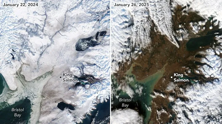
New satellite images reveal the stark pace of global warming in Alaska, with last year's snow vanishing and leaving behind miles of bare ground.
The images, taken by the Moderate Resolution Imaging Spectroradiometer (MODIS) instrument on NASA's Terra and Aqua satellites, show Bristol Bay Borough in southern Alaska. Anchorage, which is located to the northeast, had an average January snow depth of 13 inches (33 centimeters) between 1998 and 2025.
But this year, the station, alongside other parts of the state, reported next to no snow on the ground. What is left behind are large patches of ground visible from space.
"Since December 2024, temperatures across the state have been 5 to 10 degrees Fahrenheit (3 to 6 degrees Celsius) above normal, according to NOAA, and isolated areas have experienced even greater anomalies," NASA Earth Observatory wrote in a blog post accompanying the new images. "The warm temperatures caused existing snow and ice to melt and new precipitation to fall as rain."
As climate change heats up the planet, Arctic regions such as Alaska are experiencing dramatic rates of warming, with temperatures increasing up to four times faster than the rest of the world. Anchorage's average temperature was 29.3 F (minus 1.5 C) in January — 13 F (7.2 C) above average and warmer than readings taken in three dozen other states.
The reasons for this are twofold. First, unusual weather conditions across the North Pacific fueled a marine heatwave across North America this winter. This warming was worsened in Alaska thanks to a warm, high-pressure ridge of air hanging over the state.
Get the world’s most fascinating discoveries delivered straight to your inbox.
RELATED STORIES
Second, climate change is increasingly chipping away at the region's sea ice, which acts as a protective shield that reflects the sun's rays back into space But this phenomenon, known as the albedo effect, is now working in reverse, with melting sea ice uncovering darker waters that absorb more of the sun's rays.
This means that, as our planet warms, Arctic regions are transforming from planetary refrigerators to radiators. This is causing Alaska's snowpack, the snow that accumulates in winter and melts in spring, to shrink. Climate models predict that by the middle of this century, a dramatic reduction in snow pack will threaten the region's glaciers and bring stronger storms and more rainfall.
At the end of January, the dissipation of the high-pressure front led to a blast of Arctic winds that brought back sub-zero temperatures across the state. Local forecasts don't expect this to last for long, however, with warmer-than-average temperatures predicted to return to the state by mid-February.

Ben Turner is a U.K. based writer and editor at Live Science. He covers physics and astronomy, tech and climate change. He graduated from University College London with a degree in particle physics before training as a journalist. When he's not writing, Ben enjoys reading literature, playing the guitar and embarrassing himself with chess.
You must confirm your public display name before commenting
Please logout and then login again, you will then be prompted to enter your display name.