


Declassified spy satellite images reveal 1,400-year-old battle site in Iraq that set off the Muslim conquest
Historical texts that mentioned details about the battle site helped researchers match the images to the lost town of al-Qadisiyyah.
Declassified spy images of Iraq have helped archaeologists find a historic Islamic battlefield.
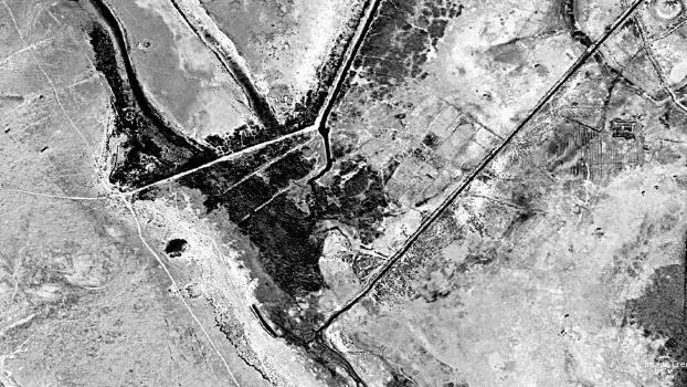
Upon analyzing the images, which were taken in 1973 by a U.S. satellite system named KH-9 (Hexagon), the team found remnants of a 1,400-year-old settlement. This helped them match the site to the lost location of the Battle of al-Qadisiyyah, the researchers reported in a study published Nov. 12 in the journal Antiquity.
The Battle of al-Qadisiyyah took place in A.D. 636 or 637 between the Arab Muslim army and the Sasanian Empire, which ruled the area that is now Iran between A.D. 224 and 651. According to Encyclopedia Britannica, the battle was a consequential victory for the Muslim army and the beginning of the eventual Muslim conquest of Persia.
But William Deadman, an archaeologist at Durham University in the U.K. and the lead author of the study, and colleagues had not originally set out to find the lost battle site. Using the 1973 satellite imagery, they were examining the Hajj pilgrimage route of Darb Zubaydah as part of its consideration as a UNESCO World Heritage Site. According to UNESCO, Darb Zubaydah connected the city of Kufa, Iraq, to Mecca, Saudi Arabia, and was the most important Hajj route between A.D. 750 and 850, during the Abbasid Caliphate, a golden age of Muslim civilization.
Related: Cold War satellite images reveal nearly 400 Roman forts in the Middle East
RELATED STORIES
As the researchers looked over the newly declassified images, they realized they might have the chance to find the lost battlefield of al-Qadisiyyah, according to a Durham University statement. Records of the battle had given clues to its location. For example, they mentioned there was a 6-mile-long (10 kilometers) wall that connected al-Qadisiyyah to a neighboring town and that the town was "south of a body of water, between [a] moat and a bridged stream," the paper noted. Using these clues, Deadman located a modern-day agricultural field that matched the description.
An on-the-ground survey confirmed the find. Researchers identified the 6-mile-long wall and the moat north of the town mentioned in historical texts.
Get the world’s most fascinating discoveries delivered straight to your inbox.
"This discovery provides a geographical location and context for a battle that is one of the founding stories of the expansion of Islam into modern day Iraq, Iran and beyond," Deadman said in the statement.

Sierra Bouchér is a Washington, D.C.-based journalist whose work has been featured in Science, Scientific American, Mongabay and more. They have a master's degree in science communication from U.C. Santa Cruz, and a research background in animal behavior and historical ecology.