It's quick and easy to access Live Science Plus, simply enter your email below. We'll send you a confirmation and sign you up for our daily newsletter, keeping you up to date with the latest science news.
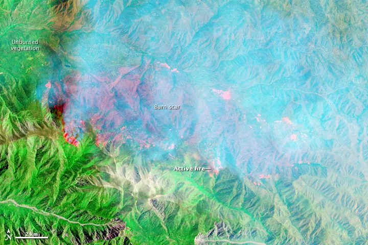
False-color image shows short-wave infrared spectrum. Hot sections of active fires are bright orange-red, and cooler, just-burned areas are dark red. NASA Earth Observatory Image by Jesse Allen, using EO-1 ALI data provided by the NASA EO-1 team. Image captured on June 20, 2015.
California's four-year-long drought is helping fuel its first major forest fire of the year, a blaze that is engulfing federal land about 80 miles (130 kilometers) east of Los Angeles. A NASA satellite captured the smoky scene from orbit, revealing the extent of the so-called Lake fire.
As of Tuesday (June 23), the fire had engulfed at least 27 square miles (70 square kilometers) of the San Bernardino National Forest. The fire was first reported on June 17, but local officials do not yet know the cause of the blaze. Around 500 structures are threatened by the flames, but none have been damaged or destroyed. Only 30 percent of the fire is currently contained, according to InciWeb, an interagency risk incident information management system run by the United States Forest Service
The satellite images were taken on Saturday (June 20), when the fire had burned about 23 square miles (60 square km) and was just 10 percent contained. The photos were snapped by the Advanced Land Imager (ALI) on the Earth Observing-1 (EO-1) satellite. [Earth from Above: 101 Stunning Images from Orbit]
In the natural-color image, a dense, white cloud of smoke can be seen blanketing San Bernardino National Forest. This same scene, when viewed in the short-wave infrared spectrum — which can peer through dense smoke to see the ground below — reveals burn scars and active fires that are normally obscured.
Natural color image by NASA Earth Observatory. Image captured on June 20, 2015.
(Image credit: Jesse Allen, using EO-1 ALI data provided by the NASA EO-1 team.)
There are currently 118 fire engines, four air tankers, 17 helicopters, four support planes, 44 crews and 1,932 people on the scene to fight the fire, InciWeb reported. Local officials estimate it will cost at least $6.8 million to contain the wildfire, the Los Angeles Times reported.
The Lake fire is burning with low intensity, allowing firefighters to safely approach and subdue the flames, which are concentrated near the Coon Creek campground within a pine forest. according to InciWeb.
The fire started last week and quickly spread up the mountains, reaching elevations of 6,000 to nearly 10,000 feet (1,830 to 3,050 meters), where the ground is normally damp from storms and, in some cases, even dusted with snow, reported the Los Angeles Times.
Sign up for the Live Science daily newsletter now
Get the world’s most fascinating discoveries delivered straight to your inbox.
"At higher elevation, normally you would have cooler temperatures and your rain and snow would linger longer into the spring or early summer," Lee Beyer, a U.S. Forest Service spokesman, told the LA Times. "That's definitely not the case this year."
William Patzert, a climatologist at the Jet Propulsion Laboratory in La Cañada Flintridge, said that the hot, dry conditions are the result of a meteorological ridge, which is a long region of high atmospheric pressure. It "makes a dry situation an incendiary situation. We expect June gloom, we don't expect these crushing high-pressure systems which are more usual in late summer, fall," he told the LA Times. "This is all part of the drought."
Elizabeth is a staff writer for Live Science. She enjoys learning and writing about natural and health sciences, and is thrilled when she finds an evocative metaphor for an obscure scientific idea. She researched ancient iron formations in China for her Masters of Science degree in Geosciences at the University of California, Riverside, and went on to Columbia Journalism School for a master's degree in journalism, focusing on environmental and science writing.

 Live Science Plus