It's quick and easy to access Live Science Plus, simply enter your email below. We'll send you a confirmation and sign you up for our daily newsletter, keeping you up to date with the latest science news.
Iceland's six-month-long volcanic eruption was over for less than a week when geologists clambered onto the cooling lava lake in Baugur crater to measure toxic gases there. [Read the full story.]
Baugur crater was the tallest and largest in the long chain of craters built by the spectacular fire fountains that exploded from the earth on Aug. 31, 2014, in remote central Iceland. The magma feeding the eruption comes from Bardarbunga volcano, located some 28 miles (45 kilometers) to the southwest. Here are some of the stunning views from inside Baugur crater on March 4, 2015.
The surface eruption, called the Holuhraun lava field, ended on Feb. 27, but volcanic gases still stream from the cooling lava. Scientists from the British Geological Survey and the Icelandic Meteorological Office plan to monitor the emissions for several months. Sulfur dioxide pollution from the huge lava flow could still reach hazardous levels in Iceland, the Met Office has warned. In this photo, geologists (in orange suits) are inside Iceland's Baugur crater on March 4, 2015. (Ármann Höskuldsson/Icelandic Met Office)
Scientists used a Dyson vacuum to retrieve samples of volcanic gas. (Photo credit: Evgenia Ilyinskaya/British Geological Survey)
Small vents of blue sulfur-dioxide gas rise from the crater, along with puffs of steaming hot water vapor. (Photo credit: Evgenia Ilyinskaya/British Geological Survey)
Geologists explore Baugur crater on March 4, 2015. (Photo credit: Evgenia Ilyinskaya/British Geological Survey)
The surface temperature inside the crater is still a red-hot 1,110 degrees Fahrenheit (about 600 degrees Celsius). The same scientists as in the previous photo are visible as cool purple figures, as seen with a thermal camera. (Photo credit: Evgenia Ilyinskaya/British Geological Survey)
Sign up for the Live Science daily newsletter now
Get the world’s most fascinating discoveries delivered straight to your inbox.
Lava flows from Baugur crater on Oct. 26, 2014. (Photo credit: Icelandic Met Office)
Geologic map of Bardarbunga volcano and Holuhraun lava field. The dotted line shows an underground magma tunnel (dike) that connects the surface eruption to Bardarbunga. (Image credit: University of Iceland)
Aerial photo of the Holuhraun lava field. (Photo credit: Ólafur Sigurjónsson/Icelandic Met Office)
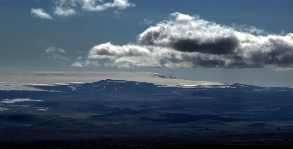
The remote Barðarbunga volcano, viewed from Askja volcano in southeast Iceland. (Photo credit: Dave McGarvie, Open University)
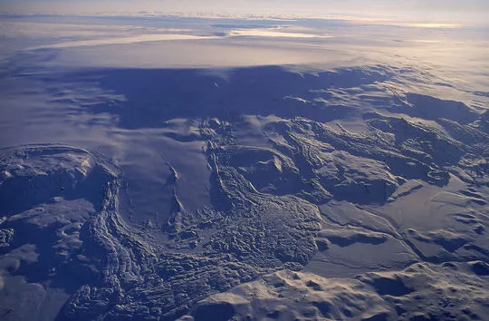
Barðarbunga volcano, covered by the Vatnajökull glacier. (Photo credit: Oddur Sigurðsson/Icelandic Met Office)
A new GPS station being installed near Gjallandi. Bardarbunga is the snow-covered peak in the distance. (Photo credit: Benedikt G. Ófeigsson/Icelandic Met Office)
The lava lake inside Baugur crater on Feb. 3, 2015. (Photo credit: Sara Barsotti/Icelandic Met Office)
Becky Oskin covers Earth science, climate change and space, as well as general science topics. Becky was a science reporter at Live Science and The Pasadena Star-News; she has freelanced for New Scientist and the American Institute of Physics. She earned a master's degree in geology from Caltech, a bachelor's degree from Washington State University, and a graduate certificate in science writing from the University of California, Santa Cruz.