It's quick and easy to access Live Science Plus, simply enter your email below. We'll send you a confirmation and sign you up for our daily newsletter, keeping you up to date with the latest science news.
Brazil may have suffered a crushing World Cup defeat at the hands of Germany yesterday (July 8), but their bad luck is, fortunately, not visible from space.
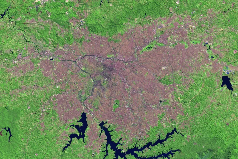
As the fifth-largest country in the world by area and the sixth-largest by population, Brazil is the economic powerhouse of South America. Its largest city, São Paulo, is seen in satellite imagery captured by the Landsat 5 and Landsat 8 satellites.
Today, São Paulo is home to 20 million people, according to the CIA World Factbook, as it is the 10th largest urban area on Earth. The newly released satellite image is of São Paulo on Sept. 1, 2013. Another view of the city, this one from 1986, reveals how much the population has grown. [Night Lights: Stunning Views of Earth after Dark]
Acquired on Aug. 6, 1986, this image shows the Brazilian city of Sao Paulo as seen by the Landsat 5 satellite.
(Image credit: NASA Earth Observatory)
Growth of a city
Released by NASA's Earth Observatory, these images show the development of buildings and roads in tan and pink, while vegetation is green. The pinker the development, the denser it is. Thus, in the 1986 image, São Paulo's dense urban core is visible, with less-dense suburbs spreading out in all directions. By 2014, the downtown is still noticeably dense, but the rapidly growing suburbs have spread even farther.
Cutting horizontally through the city is the Tietê river, which is crucial for both transportation and shipping and hydroelectric power. The river, particularly through the city, has its share of environmental problems, including industrial and household pollution. A major cleanup project beginning in the 1990s has improved wastewater treatment, but pollution drainage from city streets remains a problem.
The Pinheiros river flows into the Tietê in São Paulo. The large bodies of water at the bottom of the image are two reservoirs: the Guarapiranga reservoir on the left, and the Billings reservoir, São Paulo's largest, on the right.
Sign up for the Live Science daily newsletter now
Get the world’s most fascinating discoveries delivered straight to your inbox.
Streets and slums
Not all of the development of São Paulo has been positive. Many of the suburban neighborhoods are favelas, or slums, according to the Earth Observatory. According to the Brazilian Institute of Geography and Statistics, about 6 percent of Brazilians, or 11 million people, lived in favelas as of 2010. Income inequality in Brazil helps drive the existence of favelas, despite repeated government attempts to move people out (particularly in the 1970s, when forcible evictions were common) or gentrify these areas.
Other growth is planned. The 2013 Landsat image shows a tan line snaking around the rightmost border of the city. This is the Rodoanel Mário Covas, according to Earth Observatory. This ring road is scheduled for completion in 2015.
Editor's Note: If you have an amazing nature or general science photo you'd like to share for a possible story or image gallery, please contact managing editor Jeanna Bryner at LSphotos@livescience.com.
Stephanie Pappas is a contributing writer for Live Science, covering topics ranging from geoscience to archaeology to the human brain and behavior. She was previously a senior writer for Live Science but is now a freelancer based in Denver, Colorado, and regularly contributes to Scientific American and The Monitor, the monthly magazine of the American Psychological Association. Stephanie received a bachelor's degree in psychology from the University of South Carolina and a graduate certificate in science communication from the University of California, Santa Cruz.

 Live Science Plus