


In Photos: The Impact Craters of North America
Pingualuit crater

Pingualuit crater, captured in this aerial image taken Oct. 12, 2007, spans some 2 miles (3 km) across with its lake water having a depth of 807 feet (246 m), according to NASA's Earth Observatory. Like many other craters, this one, in northern Quebec, formed millions of years ago as a result of meteorites striking Earth's surface.
"The crater lakes hold such huge volumes of water in comparison to the surrounding glacial lakes that they're slower to respond to temperature changes," explained Reinhard Pienitz, a freshwater lake expert, in an Earth Observatory post. "Pingualuit Crater Lake is always the last to freeze in the winter and the last to melt in the spring."
Bowl City Crater
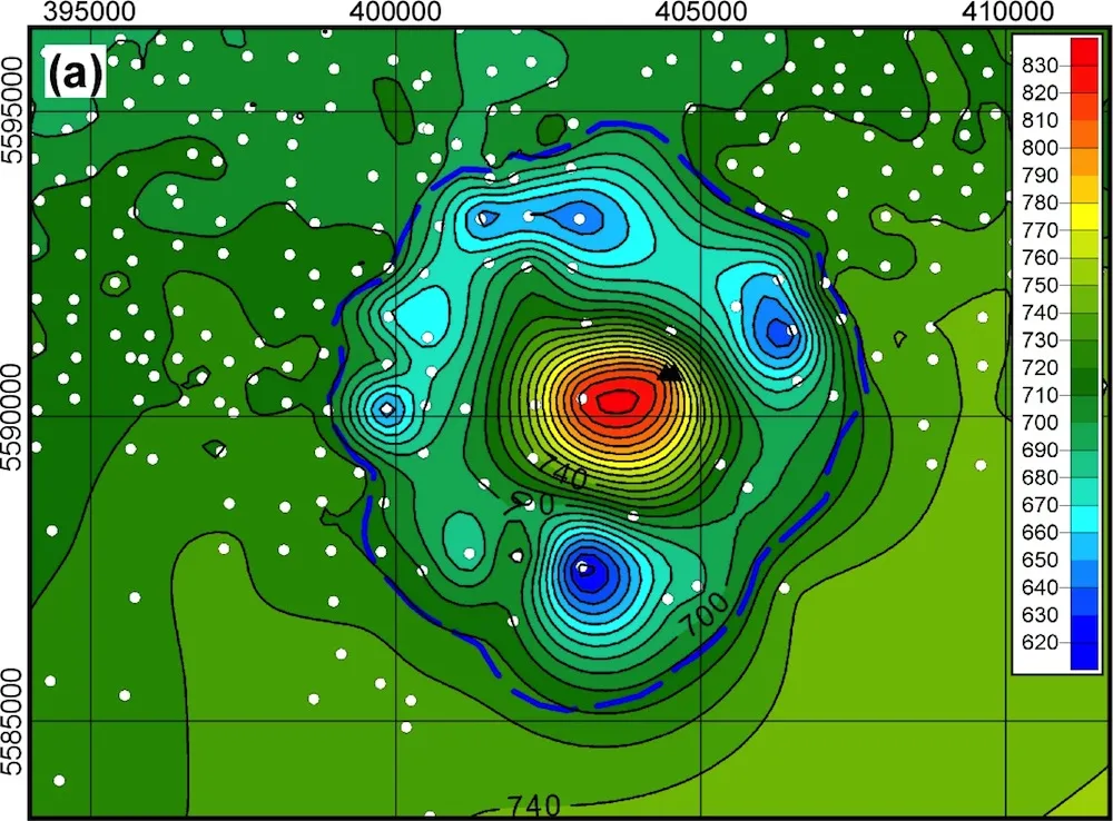
This is a map showing the structure and contour of the Bow City crater, possibly created by a giant meteorite impact. Color variation shows meters above sea level.
Couture crater

"When NASA’s Aqua satellite passed over northern Quebec on November 25, 2012, winter snow and ice had transformed the pockmarked landscape of Ungava Peninsula into a seemingly endless expanse of white. However, two areas—both near-perfect circles—remained stubbornly free of ice. Those ice-free areas, seen in the top image above, are Pingualuit and Couture craters," according to NASA's Earth Observatory.

Discovering a crater

"In 1943, the crew of a United States Army Air Force plane noticed a crater in northern Quebec, Canada. The crater’s remoteness prevented a geologic expedition until the 1950s, but once they were able to collect data from the site, geologists concluded that the structure was a meteorite crater produced from an impact roughly 1.4 million years ago. Named Pingualuit Crater in 1999, this crater’s identification eventually led to the identification of more than 20 other impact structures in eastern Canada. It has also provided useful information about climate changes during the last ice age," writes NASA's Earth Observatory.
Image captured by NASA's Landsat 7 satellite on Aug. 17, 2002.
Crater Lake

Considered the deepest lake in the United States, reaching a depth of 1,148 feet (350 m), Crater Lake in Oregon was formed from the caldera of Mount Mazama, according to NASA's Earth Observatory. When Mount Mazama erupted some 7,700 years ago it created the basin for Crater Lake. This astronaut photo was acquired July 19, 2006 from the International Space Station.
Manicouagan Crater

Considered one of the world's largest and oldest impact craters, Manicouagan Crater in Quebec, Canada, formed some 214 million years ago. Since then, erosion has done some carving, creating a ring depression (green) seen around the crater's central peak in this topographic image.
Clearwater Lakes

Landsat 8 image of Clearwater Lakes captured on June 29, 2013.
Get the world’s most fascinating discoveries delivered straight to your inbox.
Barringer Crater

Meteor Crater (also known as Barringer Crater) on Earth is only 50,000 years old. Even so, it’s unusually well preserved in the arid climate of the Colorado Plateau in Arizona. Meteor Crater formed from the impact of an iron-nickel asteroid about 46 meters (150 feet) across. Most of the asteroid melted or vaporized on impact. The collision initially formed a crater over 1,200 meters (4,000) feet across and 210 meters (700 feet) deep. Subsequent erosion has partially filled the crater, which is now only 150 meters (550 feet) deep. Layers of exposed limestone and sandstone are visible just beneath the crater rim, as are large stone blocks excavated by the impact," according to NASA's Earth Observatory.
