


Earth As Art: Land of Lakes
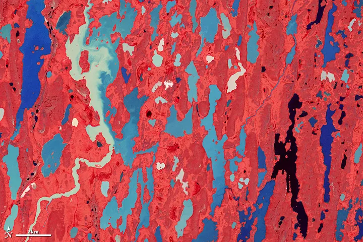
This may look like a brightly painted canvas, but it's actually the lake-covered the landscape of the Kitikmeot region of Canada's Nunavut Territory.
During the last Ice Age, nearly all of Canada was covered by massive ice sheets. When the ice retreated about 8,000 years ago, it scoured the underlying land, which was then flooded by the Arctic Ocean because it had been pushed so far down by the weight of the ice.
Gradually, the land rose — a process known as isostatic rebound — and the water stayed in only the lowest-lying parts of the landscape, creating a land of lakes, wetlands, ponds and streams seen in this false-color image taken by the Advanced Spaceborne Thermal Emission and Reflection Radiometer (ASTER) on NASA's Terra satellite on July 18, 2001..
These Arctic lowlands are covered by long, low-rising ridges of what is called glacial till — a mixture of clay, sand, gravel and boulders. Those hills are surrounded by small valleys and flatlands of marine silts and clays, which were deposited by the sea.
The region is sometimes called the "Barren Grounds," according to a NASA statement, and is largely treeless and unsuitable for agriculture. The ground is covered by snow most of the year, and permafrost (frozen soil) persists close to the ground's surface even during the summer thaw.
But even so, the ground supports vegetation such as lichen, mosses, shrubs and grasses in the summer months — these appear red in the ASTER image.
Kitikmeot is the least densely populated part of Nunavut, Canada's newest province, and wildlife such as caribou, muskox, foxes, and grizzly bears far outnumber people.
Get the world’s most fascinating discoveries delivered straight to your inbox.
