The rugged mountains of northeastern Oman, on the eastern coast of the Arabian Peninsula, are bone dry, yet these peaks once lay beneath the bottom of the sea.
The rocks exposed in the Oman Mountains used to lie in Earth’s interior, at the boundary between crust and the mantle, but when an ancient ocean narrowed and closed, the colossal geological forces at work also thrust the ancient seafloor skyward, according to a NASA statement.
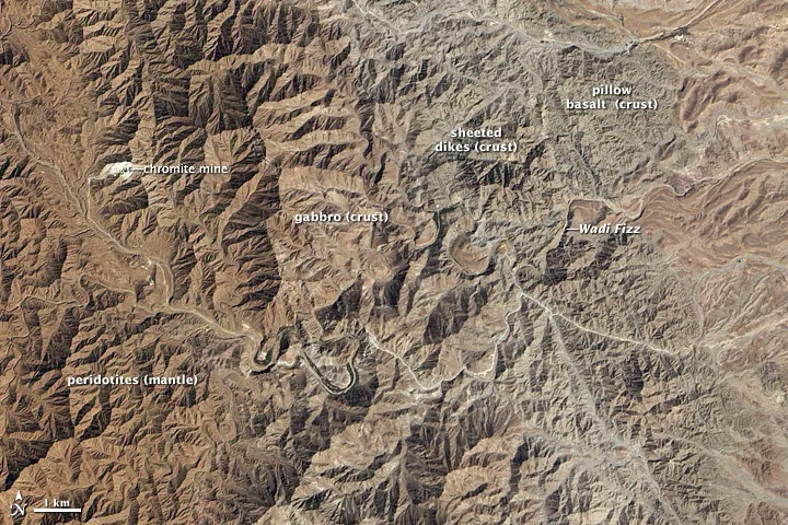
The landscape is known to geologists as the Semail (or Samail) ophiolite. Ophiolite refers to a landform where ancient oceanic crust now sits at the land surface.
Latest Videos From
The Advanced Land Imager (ALI) on NASA’s Earth Observing-1 (EO-1) satellite captured this natural-color image of a portion of the Semail ophiolite on March 6, 2012.
Different rock types that are generally inaccessible — because they usually lie below the seafloor — are visible in this image. From west to east, the rocks go from deepest within the earth to rocks that were originally exposed on the ocean floor.
At the far left are peridotites that were once part of the Earth’s mantle. The upper layer of this peridotite region was along the boundary with the base of the crust, and is where chromite is now mined.
The next layer of rocks (the first in the crust, rather than the mantle) is composed of gabbro. Farther east is a layer of sheeted dikes — lavas that were extruded into the crust, but solidified before reaching the surface. Finally, toward the eastern edge of the image, lie basalt pillow lavas, which solidified in deep water.
Follow OurAmazingPlanet for the latest in Earth science and exploration news on Twitter @OAPlanet and on Facebook.