


Incredible Images: Earth in 2011
Earth: 2011

2011 was an eventful year for the Earth and its denizens, from the massive earthquake and tsunami that devastated Japan in March to tornadoes that struck the United States heartland in late spring to the auroras that graced polar skies in winter.
These events yielded images that awe and amaze, that show the scale of the forces that shape our planet and the majesty of the landscapes on its surface. Here, we take a look back at some of the most amazing images of the year.
On the Eve of 2011
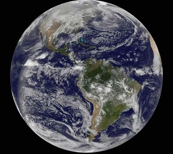
On the morning of Dec. 30, 2010, a satellite captured this stunning portrait of our planet.
Amazing Auroras
A powerful solar flare, hurled into space when superhot gases erupted on the sun on Feb, 13.
The flare triggered northern lights displays for skywatchers living in northern latitudes and graced with clear skies, including Tom Eklund of Finland, who took this photo on Feb. 14. [More aurora images.]

Japan Tsunami Damage

One of the cities hardest hit by the 9.0-magnitude earthquake and resulting tsunami that devastated Japan on March was Rikuzentakata.
The Advanced Spaceborne Thermal Emission and Reflection Radiometer (ASTER) on NASA's Terra satellite observed dramatic changes at Rikuzentakata, including in this ASTER image taken on March 14. [Video: Before and After the Tsunami]
ASTER combines infrared, red, and green wavelengths of light to make false-color images that distinguish between water and land. In these images, water is blue. Buildings and paved surfaces appear in shades of blue-gray. Agricultural fields range in color from brown to beige to pink. Vegetation is red, and brighter shades of red indicate more robust vegetation.
In the wake of the tsunami, the coastline of Rikuzentakata was totally reshaped. A long barrier island of well-vegetated land, visible in 2007, is almost completely gone from the waterfront. North of that, flood water sits on agricultural fields. East of Rikuzentakata, a large mass of peach-colored floating debris appears in the image from 2011.
Tiny Tortoise

This baby Egyptian tortoise at the Zoological Society of London's Whipsnade Zoo is only slightly bigger than this green grape. It was part of a small litter born to a group of tortoises that were destined for the illegal pet trade but were seized by British customs officials last year.
East Coast Lights at Night
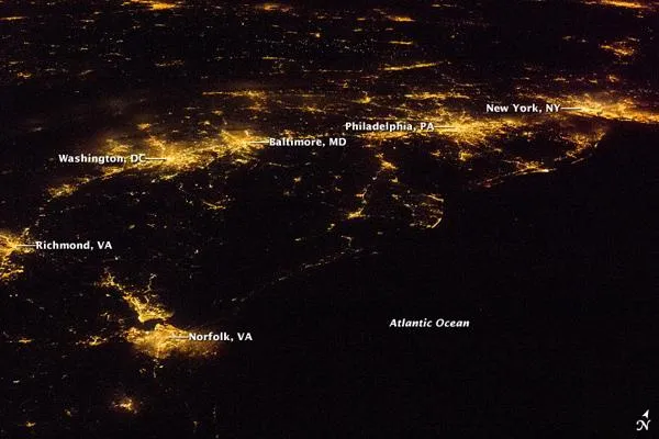
This nighttime astronaut picture highlights the patterns of lights of major East Coast cities that are visible from space.
In contrast to the city lights along the sea coast and interior, the Atlantic Ocean appears as a featureless dark region filling the lower right quarter of the image.
Texas Wildfires
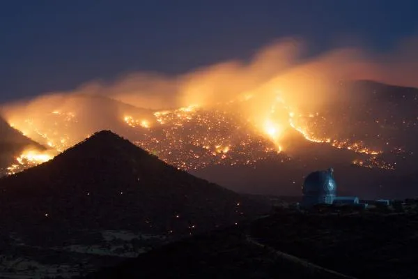
In April, the terrible Texas drought spurred on wildfires that threatened McDonald Observatory.
The telescope was shut down when the observatory lost power on April 11, as wildfires knocked out power lines in the area. The observatory's dome was shut and backup generators powered the facility.
The wildfires burned more than a million acres of the state.
Get the world’s most fascinating discoveries delivered straight to your inbox.
Undular Bore
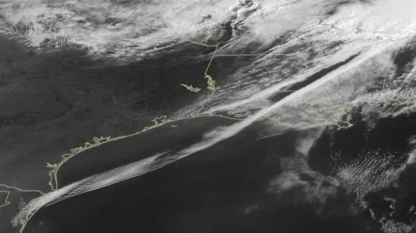
A rare cloud formation was caught by a satellite as it rolled across the Gulf of Mexico on April 27.
The formation is called an undular bore, or gravity wave train, and it appears as rarely as once a month. An undular bore is a disturbance in the Earth's atmosphere that can be seen as clouds move in waves. They normally occur within an area of the atmosphere that is stable in the low levels after a cold front moves through.
Mississippi Flooding
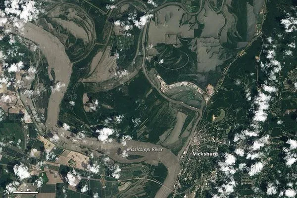
The Mississippi River was rising quickly in Vicksburg, Mississippi, when the Advanced Land Imager (ALI) on NASA's Earth Observing-1 (EO-1) satellite captured this image on May 10, 2011. The river was at 52.68 feet at 11:00 a.m., close to the time the image was taken, according to a NASA statement. The top image shows the flooded region in natural color. The muddy Mississippi appears textured in places, a testament to the turbulent flow of the swollen river.
In the days after the image was taken, water levels continued to rise in Vicksburg. By 9 a.m. on May 12, the river had reached 54.51 feet and was still rising. The river reached flood stage at 43 feet, and major flood stage at 50 feet. The record is 56.2 feet, reached on May 4, 1927.
This year's flooding was some of the worst on the Mississippi in U.S. history.
Joplin Tornado Track
The Joplin tornado struck on Sunday, May 22, as an EF-5, the strongest rating on the tornado damage scale . The twister killed 162 people, reported the Weather Channel, making it the seventh deadliest in U.S. history and the deadliest in at least 60 years. It also injured more than 1,000 and became the costliest single tornado in U.S. history.
The storm was three-quarters of a mile wide with a 300-yard-wide (274 meters) hurricane-like eye. Its winds exceeded 200 mph (322 kph). The tornado was on the ground for 6 miles (9.7 kilometers).
