The massive tsunami generated by the March 2011 earthquake off the coast of northeastern Japan was a "merging tsunami" — a type of tsunami long thought to exist, but seen now for the first time, scientists report.
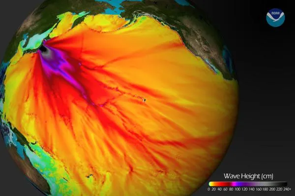
The magnitude-9.0 Tohoku-Oki temblor, the fifth-most powerful quake ever recorded, triggered a tsunami that doubled in intensity over rugged ocean ridges, amplifying its destructive power at landfall, as seen in data from NASA and European radar satellites that captured at least two wave fronts that day. The fronts merged to form a single, double-high wave far out at sea. This wave was capable of traveling long distances without losing power. Ocean ridges and undersea mountain chains pushed the waves together along certain directions from the tsunami's origin.
The discovery, presented today (Dec. 5) at the annual meeting of the American Geophysical Union in San Francisco, helps explain how tsunamis can cross ocean basins to cause massive destruction at some locations while leaving others unscathed. The data raise hope that scientists may be able to improve tsunami forecasts.
Latest Videos From
"It was a one-in-10-million chance that we were able to observe this double wave with satellites," said study team member Y. Tony Song, of NASA's Jet Propulsion Laboratory in Pasadena, Calif., who presented with team member C.K. Shum of The Ohio State University.
Right place, right time "Researchers have suspected for decades that such 'merging tsunamis' might have been responsible for the 1960 Chilean tsunami that killed about 200 people in Japan and Hawaii, but nobody had definitively observed a merging tsunami until now,” Song said in a statement. "It was like looking for a ghost. A NASA-French Space Agency satellite altimeter happened to be in the right place at the right time to capture the double wave and verify its existence." The NASA-Centre National d'Etudes Spaciales Jason-1 satellite passed over the tsunami on March 11, as did two other satellites — the NASA-European Jason-2 and the European Space Agency's EnviSAT. All three carry radar altimeters, which measure sea-level changes to an accuracy of a few centimeters. Each satellite crossed the tsunami at a different location, measuring the wave fronts as they occurred. [Video: Japan Tsunami's Effects] The researchers think ridges and undersea mountain chains on the ocean floor deflected parts of the initial tsunami wave away from each other to form independent jets shooting off in different directions, each with its own wave front.
Better risk maps The sea floor topography nudges tsunami waves in varying directions and can make its destruction appear random. For that reason, hazard maps that try to predict where tsunamis will strike rely on sub-sea topography. Previously, these maps considered only topography near a particular shoreline. This study suggests scientists may be able to create maps that take into account all undersea topography, even sub-sea ridges and mountains far from shore.
"We can use what we learned to make better forecasts of tsunami danger in specific coastal regions anywhere in the world, depending on the location and the mechanism of an undersea quake," Shum said. Song and his team were able to verify the satellite data through model simulations based on independent data, including GPS data from Japan and buoy data from the National Oceanic and Atmospheric Administration's Deep-Ocean Assessment and Reporting of Tsunamis program. "Tools based on this research could help officials forecast the potential for tsunami jets to merge," Song said. "This, in turn, could lead to more-accurate coastal tsunami-hazard maps to protect communities and critical infrastructure."
Follow OurAmazingPlanet for the latest in Earth science and exploration news on Twitter @OAPlanet and on Facebook.

 Live Science Plus