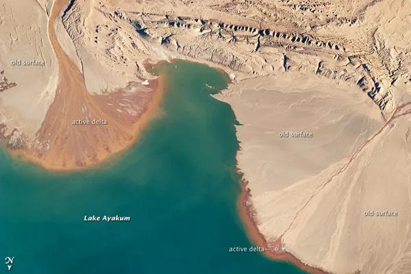
Numerous lakes dot the otherwise arid landscape of the Tibetan Plateau. One of those lakes is Ayakum, near the northern boundary of the Plateau, to the southeast of the Kunlun Mountains.
While many of the small glacier- and snowmelt-fed streams on the Plateau give rise to major Southeast Asian rivers (including the Mekong and Yangtze), some empty into saline lakes such as Lake Ayakum. This astronaut photograph highlights two river deltas formed along its southwestern shoreline.
When sediments build up to the point that a river can no longer flow over them, the river will jump to a new channel and begin the process anew. Over geologic time, the channels tend to sweep back and forthsimilar to the motion of a windshield wiperto form the semi-circular or fan shape typical of a delta.
Latest Videos From
Gray to tan surfaces indicate prior positions of the river channels; the uniform coloration and smooth texture suggest that they are relatively old and now inactive. By contrast, the younger and currently active delta surfaces have reddish-brown sediment and visible river channels.
Lateral channel migration is particularly evident in the approximately 8-kilometer (5-mile) wide active delta at image upper left. The reddish color of the fresh sediment may indicate a change from the sources that formed the older parts of the deltas. It might indicate weathering and soil formation on the older deposits. It could even be a sign of episodic inputs of dust or other material to the river catchments.