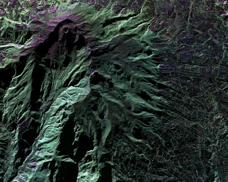
This false-color image of Colombia's Galeras Volcano, was acquired by UAVSAR on March 13, 2013. A highly active volcano, Galeras features a breached caldera and an active cone that produces numerous small to moderate explosive eruptions. It is located immediately west of the city of Pasto.
NASA's globe-trotting, remote-sensing plane wrapped up a month-long trip to Central and South America in March, returning with images of volcanoes, Amazon floods and archaeological sites.
The small Gulfstream-III passenger plane carries a 10-foot-long (3 meters) radar pod, the unmanned aerial vehicle synthetic aperture radar (UAVSAR). The radar scans Earth's surface with radio waves to detect and measure changes of less than half an inch (1 centimeter). In past years, flight passes included volcanoes, glaciers, earthquakes and landslides.
This March, researchers had a long list of targets to hit in Central and South America. But first, they flew over groundwater basins in Arizona's Cochise County for the Arizona Department of Water Resources, to monitor seasonal changes in the surface elevation that reveal clues to the groundwater stored beneath.
In Central America, the radar team looked at coastal mangrove forests and active volcanoes. In South America, the sites ranged from Chilean wineries and shrinking tropical glaciers to Amazon cloud forests and Moche culture archaeological sites in Peru.
On March 17, 2013, NASA's Uninhabited Aerial Vehicle Synthetic Aperture Radar (UAVSAR) acquired synthetic aperture radar data over the Napo River in Ecuador and Peru.
(Image credit: NASA/JPL-Caltech)
"The radar is sensitive to water content of soil, and soil moisture constrains a lot of ecosystem processes," Yang Zheng, UAVSAR operational processing lead, told OurAmazingPlanet during a UAVSAR demo at NASA's Dryden Flight Research Center in January. In the world's forests, "We're trying to make the step from knowing where there's forest to how much carbon is stored in the forest and understanding carbon processes," said Zheng, who is based at NASA's Jet Propulsion Laboratory in Pasadena, Calif.
The UAVSAR data is higher resolution, with less interfering noise than most such data from satellites, according to NASA. Its GPS system flies the plane in a line with real-time corrections via satellite phone, providing global coverage.
"We can fly within a 10-meter tube," said Naiara Pinto, UAVSAR science coordinator, at the Dryden flight demo.
Sign up for the Live Science daily newsletter now
Get the world’s most fascinating discoveries delivered straight to your inbox.
Becky Oskin covers Earth science, climate change and space, as well as general science topics. Becky was a science reporter at Live Science and The Pasadena Star-News; she has freelanced for New Scientist and the American Institute of Physics. She earned a master's degree in geology from Caltech, a bachelor's degree from Washington State University, and a graduate certificate in science writing from the University of California, Santa Cruz.