Striking 'Cloud Streets' Seen From Space
Get the world’s most fascinating discoveries delivered straight to your inbox.
You are now subscribed
Your newsletter sign-up was successful
Want to add more newsletters?
Delivered Daily
Daily Newsletter
Sign up for the latest discoveries, groundbreaking research and fascinating breakthroughs that impact you and the wider world direct to your inbox.
Once a week
Life's Little Mysteries
Feed your curiosity with an exclusive mystery every week, solved with science and delivered direct to your inbox before it's seen anywhere else.
Once a week
How It Works
Sign up to our free science & technology newsletter for your weekly fix of fascinating articles, quick quizzes, amazing images, and more
Delivered daily
Space.com Newsletter
Breaking space news, the latest updates on rocket launches, skywatching events and more!
Once a month
Watch This Space
Sign up to our monthly entertainment newsletter to keep up with all our coverage of the latest sci-fi and space movies, tv shows, games and books.
Once a week
Night Sky This Week
Discover this week's must-see night sky events, moon phases, and stunning astrophotos. Sign up for our skywatching newsletter and explore the universe with us!
Join the club
Get full access to premium articles, exclusive features and a growing list of member rewards.
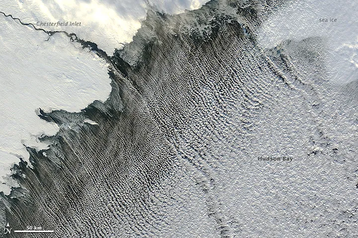
Trapped beneath a warm air layer and directed by a cold northwesterly wind, fluffy cumulus clouds line up in bands called 'cloud streets' in an image captured Nov. 13 by NASA's Terra satellite.
The visible light image by the satellite's Moderate Resolution Imaging Spectroradiometer (MODIS) shows skinny, northwest-oriented clouds filling Hudson Bay in northeastern Canada.
Cloud streets — long parallel bands of cumulus clouds — form when cold air blows over warmer waters, while warmer air called an inversion layer rests on top of both, according to NASA's Earth Observatory.
When heat and moisture from the comparatively warm water rise through the cold air above, the rising thermals hit the inversion layer, which acts like a lid. The thermals roll over and loop back on themselves, creating parallel cylinders of rotating air. As this happens, the moisture in the warm air cools and condenses into flat-bottomed, fluffy-topped cumulus clouds that line up parallel to the prevailing wind.
Follow OurAmazingPlanet on Twitter @OAPlanet. We're also on Facebook and Google+.
Get the world’s most fascinating discoveries delivered straight to your inbox.

