10 things you need to know about Arctic sea ice

The Planet's White Cap

The bright white central mass shows the perennial sea ice, which is just the multi-year ice that has survived at least one summer, while the larger light blue area shows the full extent of the winter sea ice including the average annual sea ice during the

The bright white central mass shows the perennial sea ice, which is just the multi-year ice that has survived at least one summer, while the larger light blue area shows the full extent of the winter sea ice including the average annual sea ice during the 2012 months of November, December and January. (Image credit: NASA/Goddard Scientific Visualization Studio.)

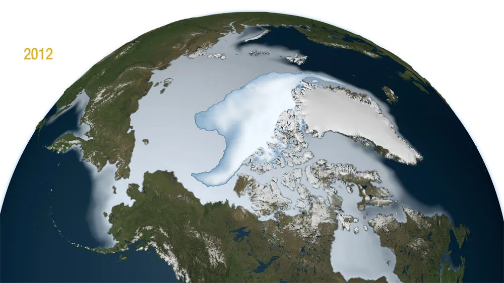
Much of the Arctic is covered by ocean, which, in turn, is covered by a layer of ice for much of the year. The extent of the ice grows and recedes with the seasons. But in recent years this cycle has shifted as melt has increased and the sea ice has crept back to unprecedented lows. Find out what’s going on and why it matters.

What is it?

Sun sets over Greenland's sea ice.

Sun sets over Greenland's sea ice. (Image credit: courtesy Andy Mahoney, NSIDC)

Sea ice forms and floats in Arctic and Antarctic waters. By contrast, icebergs, glaciers and ice shelves all originate on land.

An Annual Cycle

Sea ice in the Chukchi Sea

Sea ice in the Chukchi Sea, on July 20, 2011. Scientists are setting out to conduct the first comprehensive study of marine life in the Chukchi Sea. (Image credit: NASA/Kathryn Hansen)

In the Arctic, sea ice grows during the winter, usually reaching its greatest extent in March. Then it begins melting. The melt usually lasts into mid-September, when the sea ice reaches its lowest extent. Then, it begins to reform.

What Is Happening to It?

Daily Arctic sea ice extent on September 10, 2010, the reported minimum extent for the year. The orange line indicates the median extent for that same day from 1979 to 2000. The black cross marks the geographic North Pole.

Daily Arctic sea ice extent on September 10, 2010, the reported minimum extent for the year. The orange line indicates the median extent for that same day from 1979 to 2000. The black cross marks the geographic North Pole. (Image credit: National Snow and Ice Data Center.)

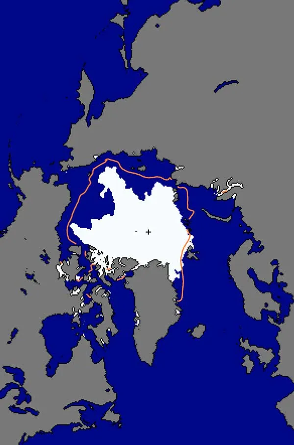
In recent years, the Arctic sea ice extent has been melting. Satellite records for Arctic sea ice extent go back into the late 1970s, but recent years have brought unprecedented lows. Above, the minimum sea ice extent on Sept. 10, 2010. The orange line indicates the median extent for that same day from 1979 to 2000. The black cross marks the geographic North Pole.

What is Causing the Melt?

Beaufort Sea arctic ice reaches new low

Melting ice on the Beaufort Sea in the Arctic. The summer extent of the ice reached its second lowest point since 2007 on Sept. 9, 2011, since the record low of 2007, according to the National Snow and Ice Data Center. (Image credit: Rear Admiral Harley D. Nygren, NOAA Corps (ret.)/NOAA, Dept. of Commerce)

Scientists attributed the increased loss of sea ice in recent years to a combination of natural fluctuations and to human-caused climate change, which is warming the planet. Natural events can influence the rate at which the melt occurs. For instance, a storm in early August 2012 may have caused the rate of sea ice retreat to spike.

How Is Sea Ice Measured?

Sea ice around Deception Island

Sea ice around the Antarctic's Deception Island. 'Actually, in the 90's it was thought that the climate change would favor the chinstrap penguin, because this species prefers sea waters without ice unlike the Adelie penguin which prefers the ice pack,' study researcher Andres Barbosa told LiveScience. The sea-ice decline in the winter, however, has become so big that it is now impacting krill populations, said Barbosa, of the National Museum of Natural Sciences in Madrid. (Image credit: Andres Barbosa)

The U.S. National Snow and Ice Data Center determines sea ice extent by looking at the proportion of Arctic water covered 15 percent or more by ice.

Who Needs It?

tens of thousands of walruses gather on Alaskan shores as sea ice melts

Walruses gathered on Alaskan shores of the Chukchi Sea by the tens of thousands in late August and September of 2010 after the last of the sea ice dissipated. (Image credit: USGS)

Arctic sea ice provides important habitat for walruses and polar bears. Recent declines in sea ice are creating problems for these animals. For instance, when the summer melt pushes sea ice unusually far from land over deep waters, walruses swarm onto beaches. Under normal conditions, the animals forage in shallower waters from the ice.

Bad for Bears

Polar bears are getting smaller because of climate change, and many other organisms will too, scientists say.

The Arctic sea ice has shrunk to new lows in recent years, due in part to human-caused global warming. This has had a direct effect on animals that live on the ice, such as polar bears. Research has linked declining sea ice with smaller body size and less reproduction among polar bears. Some scientists say we can expect to see many other organisms shrink in response to climate change. (Image credit: World Wildlife Fund)

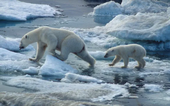
Sea ice provides important habitat for polar bears, and the loss of summer sea ice in recent years forces the bears to make long swims, which researchers worry could drown cubs.

Part of the Earth's Energy Budget

(Image credit: NASA)

Because of sea ice is white, it reflects 80 percent of the sunlight that strikes it back out into space. When sea ice melts, the dark ocean below it absorbs 90 percent of the energy. As a result, the oceans warm up, according to the U.S. National Snow and Ice Data Center. This is why scientists believe the loss of sea ice will aggravate global warming; more open water will absorb more energy absorbed into the natural system.

A Fabled Passage

Ice melting in the Northwest Passage

This image, taken on Aug. 3, 2012, shows that most of the ice in the Parry Channel, part of the Northwest Passage, has melted away. (Image credit: NASA Earth Observatory)

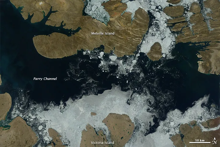
Unusual large ice melt in recent years made the fabled Northwest Passage, which links the Atlantic and Pacific Oceans, a reality for Arctic waters. This image, taken on Aug. 3, 2012, shows that most of the ice in the Parry Channel, part of the Northwest Passage, has melted away. The passage first opened in 2007.

How about Antarctic Sea Ice?

Sea ice around Antarctica.

Sea ice around Antarctica. (Image credit: John Turner/British Antarctic Survey)

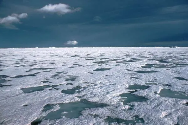
Antarctic and Arctic sea ice are quite different. While Arctic sea ice forms over the ocean, Antarctic sea ice forms around a continent. Sea around much, but not all, of Antarctica has actually increased a small amount recently. Scientists believe the Arctic sea ice is more sensitive to the larger climate system than Antarctic ice, according to the National Snow and Ice Data Center. Above, Antarctic sea ice.

Wynne Parry
Wynne was a reporter at The Stamford Advocate. She has interned at Discover magazine and has freelanced for The New York Times and Scientific American's web site. She has a masters in journalism from Columbia University and a bachelor's degree in biology from the University of Utah.