Read the latest science news and recent scientific discoveries on Live Science, where we've been reporting on groundbreaking advances for over 20 years. Our expert editors, writers and contributors are ready to guide you through today's most important breakthroughs in science with expert analysis, in-depth explainers and interesting articles, covering everything from space, technology, health, animals, planet Earth, and much more.


-
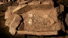
 Archaeologists find 2,800-year-old burial of person clutching sea turtle vessel in El Salvador
An unusual 2,800-year-old Mesoamerican burial found in El Salvador included a face-down skeleton clutching a sea turtle vessel.
americas -
 No, OpenAI's models didn't go 'rogue' when they broke into Hugging Face. Here's what really happened.
Analysis Experts say the models didn't "go rogue" when they escaped a controlled cybersecurity test and hacked Hugging Face. Instead, they were pursuing the goal humans had given them in ways nobody anticipated.
2 CommentsAnalysis -
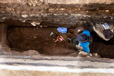
 1,200-year-old infant burial found near famous Temple of Artemis in Turkey contains twins — one with an unusual extra rib
The two infants buried in the same Byzantine-era grave may have been twins who died around the time of birth.
archaeology -
 Cyclospora parasite outbreak linked to lettuce expands to 9 states, with over 1,900 people sickened
Additional states have been added to the list of locations impacted by an outbreak of foodborne illness tied to iceberg lettuce.
viruses-infections-disease -
 6-year-old in China dies after experimental treatment, investigation finds, raising questions about the country's gene therapy regulations
A young girl in China died after being given an experimental gene therapy intended to treat a neurodevelopmental syndrome, an investigation by Science and Retraction Watch revealed.
genetics -
 Scientists discover chunk of the universe's missing matter hiding between galaxies
The total amount of ordinary matter in our universe adds up to roughly one-tenth of what's expected. Now, scientists think they may have found some of it between galaxies.
astronomy -
 AI web browsers 'aren't ready for the public,' scientists warn as they highlight massive security red flags
By enhancing the functionality of agentic browsers, they have become insecure and could be sharing personal information.
computing -
 Mathematician Hong Wang becomes third woman to win the Fields Medal, one of the world’s most prestigious math prizes
Hong Wang, a mathematician at New York University, helped solve a decades-old geometry problem and is now the third woman to win math's most prestigious award.
mathematics -
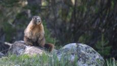 'We're trying this out of frustration': Marmots star in OnlyFans account as researchers desperately look for ways to raise funds amid US budget cuts
As U.S. federal research budgets continue to be slashed, a team of marmot researchers have turned to unconventional sources of funding.
land-mammals -
 'Extremely rare' Roman military camp found in Slovakia holds hastily buried remains of Marcus Aurelius' soldiers — with some dumped in wells
Archaeologists found a Roman military camp in Slovakia with unusual burials of soldiers who likely fought in Marcus Aurelius' Marcomannic Wars.
romans -
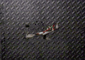 Meet Phantom Twist, a stealthy new drone that hides in plain sight by tricking your eyes
High-speed rotation exploits the concept of motion blur to conceal a new drone while it's in flight.
robotics -
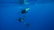 'It was unlike anything I'd witnessed before': Orcas seen headbutting a sunfish so hard that it exploded
In two encounters in the Gulf of California, one orca held a dead sunfish in place while another rammed it at high speed, breaking the carcass into what appear to be bite-sized pieces for younger whales.
orcas -
 'Once we were like you': Striking reconstructions reveal the faces of 16 people from Roman-era Hungary
DNA analysis, 3D-printed skulls and forensic sculpture helped experts recreate people who lived near the ancient Roman frontier city of Aquincum nearly 1,700 years ago.
romans -
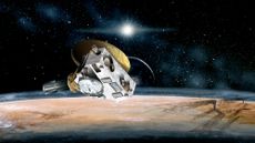 NASA awakens New Horizons spacecraft to do science billions of miles beyond Pluto
NASA's record-breaking New Horizons spacecraft has awoken from a 321-day hibernation in "good health" as it resumes unprecedented science at the solar system's edge.
3 Commentsspace-exploration -
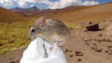 Mice on 'godforsaken' frozen volcanoes eat toxic plants to survive conditions 'not remotely compatible with long-term human survival'
Researchers risked their lives to study Andean leaf-eared mice on the inhospitable peaks of the Puna de Atacama volcanoes in Chile.
land-mammals -
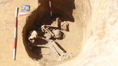
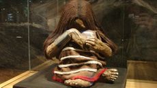 Sacrificed Inca children died very differently than we thought, study finds
A new look at three children who died in the Inca human sacrifice ceremony known as Capacocha reveals their last few months and moments.
americas -
 NASA shares image of impossible-looking crystal growing on the space station. What is happening?
Astronauts grew a scroll-like crystal aboard the ISS, and its strange shape reveals what happens to ordinary salts once gravity stops running the show.
chemistry -
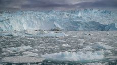 Greenland meltwater will drive a 'strong weakening, but not a shutdown' of key Atlantic currents, study finds
New modeling suggests meltwater from the Greenland ice sheet has a big weakening influence on the Atlantic Meridional Overturning Circulation, but the runoff likely won't cause a complete and irreversible collapse.
rivers-oceans -
 Startup's 'oscillator-based' AI technology could be 1,000 times more energy efficient than conventional computing
Engineers say an AI image generator built on a new type of physical computing could use far less power than existing stable diffusion-based methods.
artificial-intelligence


