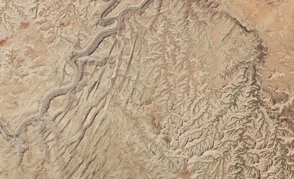
Parallel valleys called grabens stand out in a new satellite image of Canyonlands National Park in Utah.
This year is the 50th anniversary of the park, which was created in 1964. The Colorado River, seen on the left in this image, and the Green River divide the park into four districts. The region seen here is called the Needles District, which is one of the more remote areas of the park. Here, colorful sandstone spires define the landscape.
The spires may not be visible from space, but another intriguing feature of Canyonlands is: The long, parallel valleys seen alongside the Colorado River here are grabens. Each is as deep as 246 feet (75 meters) and extends about 16 miles (25 kilometers), according to NASA's Earth Observatory. The Operational Land Imager instrument on the Landsat 8 satellite took this snapshot of the grabens on May 13.
Latest Videos From
Grabens, according to the U.S. Geological Survey, are blocks of rock that have dropped down as the Earth's crust pulls apart. The ridges along the valleys are called horsts. [Photos of the 10 Least Visited National Parks]
The layer-cake look of Canyonlands originated millions of years ago, when rivers and wind brought eroded sediment from the ancestral Rockies and Appalachians to the region, according to the National Park Service (NPS). Meanwhile, about 20 million years ago, the entire region began to lift above its surroundings, a phenomenon that created the modern-day Colorado Plateau. Rivers and rain have since sculpted the soft sedimentary rocks of Canyonlands into the bizarre and amazing formations seen today.
The grabens of Canyonlands began to form about 300 million years ago, according to the NPS. During this time, the region was under a shallow inland sea, which deposited a layer of evaporated salt. When sea levels dropped, sediment continued to accrue over this layer, which is known as the Paradox Formation.
These overlying layers squeeze the Paradox Formation westward. The Colorado River has cut down through the sediments, creating a low-pressure spot that acts like a drain, drawing the salt sediments. These factors, among others, cause the land to pull apart and drop down, creating the alternating graben-horst landscape. Cracks that formed during the uplift of the Colorado Plateau define the edges of the grabens.
The Paradox Formation also plays a role in the sandstone spires that give The Needles region its name. The stretching surface caused by the movement of the Paradox Formation creates north-to-south fractures. (A regional warping called the Monument Uplift creates east-to-west fractures in the area.) Water worms its way into these fractures, eroding away the softest rock and leaving impressive, and colorful, spires behind.
Editor's Note: If you have an amazing weather or general science photo you'd like to share for a possible story or image gallery, please contact managing editor Jeanna Bryner at LSphotos@livescience.com.
Follow Stephanie Pappas on Twitter and Google+. Follow us @livescience, Facebook & Google+. Original article on Live Science.

 Live Science Plus