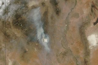
Pyrocumulus Cloud Spotted from Space

A wildfire has been raging across southwestern New Mexico all week and a NASA satellite has captured an image of a so-called pyrocumulus cloud towering above the smoke.
Pyrocumulus clouds are associated with fires or volcanic activity and they form when intense heat pushes air high into the atmosphere. The cloud that took shape this week over the fire east of Silver City, N.M., stretched between 6 and 7 miles (10 and 11 kilometers) high with top temperatures about 20 degrees Celsius (36 degrees Fahrenheit) warmer than other nearby clouds, according to NASA's Earth Observatory.
The Moderate Resolution Imaging Spectroradiometer (MODIS) on NASA's Aqua satellite snapped an image of the cloud on Wednesday (June 12).
Pyrocumulus clouds sometimes help dampen fires by dumping rain on the flames. But they also threaten to propel fires with strong, erratic winds and can send smoke and pollutants high into the atmosphere, which can affect air quality over a broad area, depending on wind patterns.
The Silver Fire was sparked by lightning on June 7 and it has been burning through the Gila National Forest, east of Silver City. As of the morning of Friday June 14, the fire's size was 21,400 acres (8,660 hectares).
Follow Megan Gannon on Twitter and Google+. Follow us @livescience, Facebook & Google+. Original article on LiveScience.com.
Sign up for the Live Science daily newsletter now
Get the world’s most fascinating discoveries delivered straight to your inbox.

Most Popular

