
Snowstorm Threatens Power Outages DC to Philly
This article was provided by AccuWeather.com.
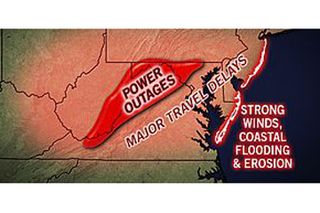
Impacts from a storm targeting millions of people in the eastern states will range from travel disruptions and power outages caused by heavy snow to coastal flooding from storm surge.
For information on snow farther north consult: "Snow New York City to Boston and New England."
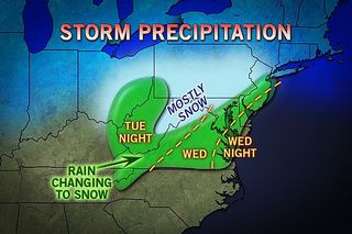
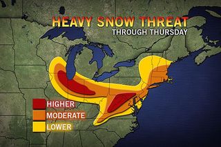
A major storm will bring heavy snow from parts of North Carolina to portions of West Virginia, Pennsylvania and New Jersey spanning later Tuesday into Thursday.
The storm will be moving through the central Appalachians toward the mid-Atlantic coast during the middle of the week, after blasting portions of the Plains and Midwest Monday into Tuesday.
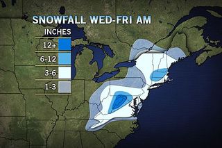
Based on the latest information, the area that has a significant chance of immobilizing snow of over a foot lies across the higher elevations of eastern West Virginia into western parts of Virginia and western Maryland.
Charlottesville, Harrisonburg and Winchester, Va.; Frederick and Hagerstown, Md. and Martinsburg, W.Va. appear to have some of the greatest snow potential. This potential would be dangerous, travel-halting snow. The weight of heavy snow is likely to bring down many trees and power lines in this area.
Sign up for the Live Science daily newsletter now
Get the world’s most fascinating discoveries delivered straight to your inbox.
However, dozens of other cities in the region and towns and rural areas in between could receive anywhere from a couple of inches of slush to a foot or more of back-breaking snow and power outages. These include Washington, D.C., Baltimore, Md., Philadelphia, New York City, Dover, Del. and Vineland, N.J. These areas are likely to receive rain during part of the storm and a larger percentage of the snow that falls is more likely to melt for a time.
As the rate of snow becomes heavy, roads can quickly become clogged with snow, potentially stranding motorists. Deicing time will increase at area airports in the path of the storm. Flight delays and cancellations from heavy snow were hitting Minneapolis and Chicago first, but will spread to multiple airports in the I-95 mid-Atlantic with the possibility of delayed aircraft and crews elsewhere across the nation. Even in parts of the South, including Atlanta the storm will have direct impact from downpours and gusty thunderstorms.
Other Stories of Interest: Snow to Reach New York City to Boston, New England Mid-Atlantic: Heavy Wet Snow, Wind and Power Outages East Storm: Wind, Beach Erosion and Coastal Flooding
Marginal temperatures will play a role, which will cause some of the snow to melt as it falls on the roads and to bring rain during part of the storm. However, when the precipitation comes down hard it can switch over to snow and quickly accumulate even on paved and concrete surfaces.
Along the coast, the storm will also cause strong winds, as well as water rise issues and beach erosion. For more information on this consult the story "East Storm: Wind, Beach Erosion and Coastal Flooding."
AccuWeather.com will continue to keep you updated on this storm until it heads out to sea Friday through videos, blogs, weather news stories and informative graphics. This story was published at 12:15 p.m. EST, Sun., Mar 3, 2013 and will be updated periodically. The most recent update was at 9:15 a.m. Tues.
© AccuWeather.com. All rights reserved. More from AccuWeather.com.
With much of the country experiencing an unseasonably warm winter, fears of climate change come to mind. See how well you understand recent weather, climate and the difference between them.
Weather vs. Climate Change: Test Yourself

Most Popular

