Watch 'unprecedented' animation showcasing 100 million years of Earth history
A new model shows how the planet's surface evolved over the past 100 million years, from the shifting of tectonic plates to the movement of sediments.

Get the world’s most fascinating discoveries delivered straight to your inbox.
You are now subscribed
Your newsletter sign-up was successful
Want to add more newsletters?

Delivered Daily
Daily Newsletter
Sign up for the latest discoveries, groundbreaking research and fascinating breakthroughs that impact you and the wider world direct to your inbox.

Once a week
Life's Little Mysteries
Feed your curiosity with an exclusive mystery every week, solved with science and delivered direct to your inbox before it's seen anywhere else.

Once a week
How It Works
Sign up to our free science & technology newsletter for your weekly fix of fascinating articles, quick quizzes, amazing images, and more

Delivered daily
Space.com Newsletter
Breaking space news, the latest updates on rocket launches, skywatching events and more!

Once a month
Watch This Space
Sign up to our monthly entertainment newsletter to keep up with all our coverage of the latest sci-fi and space movies, tv shows, games and books.

Once a week
Night Sky This Week
Discover this week's must-see night sky events, moon phases, and stunning astrophotos. Sign up for our skywatching newsletter and explore the universe with us!
Join the club
Get full access to premium articles, exclusive features and a growing list of member rewards.
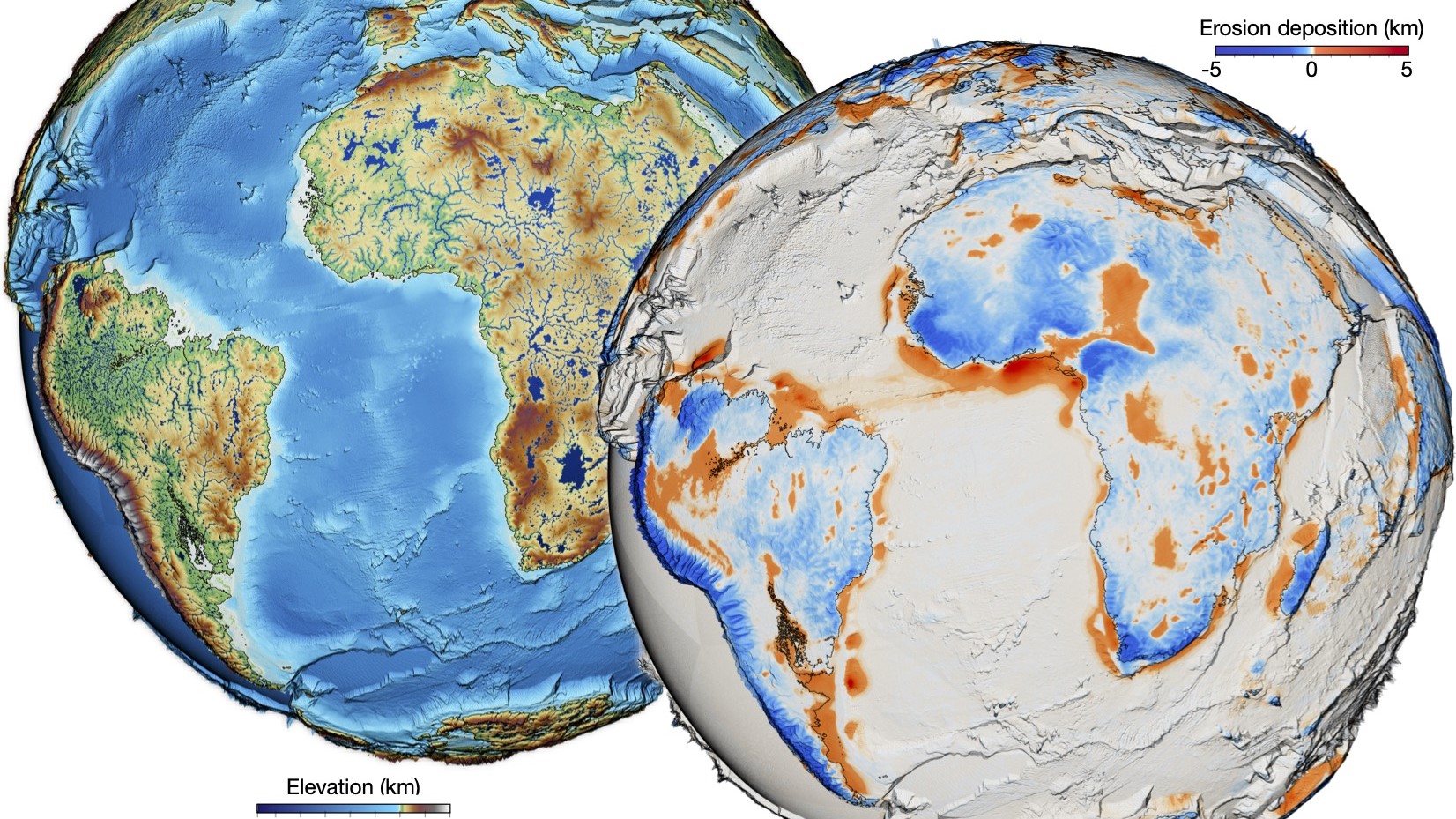
New "unprecedented" animations of the Earth show how the planet's surface has shifted and changed over the past 100 million years.
These animations are the most detailed view of the history of Earth's topography ever, depicting the rise of mountains, the development of basins, and the transport of large masses of sediments around the globe through erosion.
The animations show the movements of tectonic plates, the large rafts of crust that bump up against each other to form mountain ranges and pull apart to form ocean basins. When these plates dive into the mantle, or Earth's middle layer, at subduction zones they give rise to planet-shaping volcanoes and earthquakes. But there are other forces shaping the surface, too: Precipitation erodes away the surface, while the rate of weathering alters levels of carbon dioxide in the air, creating a feedback loop that links the land to the atmosphere.
"While the dance of the continents has been studied extensively, we are still limited in our understanding and representation of how the Earth's surface has evolved," said Tristan Salles, a senior lecturer in geosciences at the University of Sydney and the lead author of a new paper describing the model, which was published March 2 in the journal Science.
"What we bring with this new model," Salles wrote in an email to Live Science, "is a way to evaluate how this surface has changed (globally and over geological time scales) shaped by its interactions with the atmosphere, the hydrosphere, the tectonic and mantle dynamics."
Related: A tiny magma blob may rewrite Earth's history of plate tectonics
The model begins 100 million years ago in the midst of the breakup of the supercontinent Pangaea, which started to occur around 200 million years ago. In the beginning of the animation, the continents that will become Africa and South America are already recognizable, with the Northern Hemisphere continents coming together tens of millions of years later. Blue shows the flow of water, while red shows the intensity of the deposition of new sediments by erosion.
Get the world’s most fascinating discoveries delivered straight to your inbox.
"This unprecedented high-resolution model of Earth's recent past will equip geoscientists with a more complete and dynamic understanding of the Earth's surface," study co-author Laurent Husson, a geologist at the Institute of Earth Sciences (ISTerre) in Grenoble, France, said in a statement.
Putting together all of these different pressures on the evolution of Earth, from the movements of the plates to the flow of water to the slow changes in the mantle, provides a new way to ask questions about everything from the regulation of the climate to the ways the circulation of the atmosphere affect erosion on land.
The researchers found that the rate of sediment movement across the globe was likely much larger than what scientists believe based on observation, probably because the sedimentary record is fragmented. Overall erosion rates have been fairly steady for the past 100 million years, Salles said, but there have been changes in whether the sediment ends up trapped in low-elevation basins on land or ultimately flows out to sea. For example, there was a doubling of sediment flow to the oceans between about 60 million and 30 million years ago, which was likely associated with the rise of the Himalaya Mountains and the Tibetan Plateau, the researchers wrote.
Such nuances could be important, Salles said. For example, some of the earliest life formed in shallow marine environments, where microorganisms harnessed photosynthesis for the first time and left behind mineralized formations known as stromatolites.
"It is thought that sedimentation flux may have provided a source of nutrients to these early organisms, allowing them to thrive and evolve over time," Salles said. "We envision that our model could be used to test such long-standing hypotheses regarding the origin of life on Earth."

Stephanie Pappas is a contributing writer for Live Science, covering topics ranging from geoscience to archaeology to the human brain and behavior. She was previously a senior writer for Live Science but is now a freelancer based in Denver, Colorado, and regularly contributes to Scientific American and The Monitor, the monthly magazine of the American Psychological Association. Stephanie received a bachelor's degree in psychology from the University of South Carolina and a graduate certificate in science communication from the University of California, Santa Cruz.
 Live Science Plus


