An enormous dust cloud dubbed "Godzilla" that surged over the Sahara Desert in June and then blew toward the U.S. may have reached its record-breaking size and density due to warming in the Arctic.
Unusual wind patterns near the coast of western Africa whipped the Sahara storm to its gargantuan size, and could have been caused by reduced sea ice and rising ocean temperatures, according to research presented on Monday (Dec. 7) at the annual meeting of the American Geophysical Union (AGU), held virtually this year due to the COVID-19 pandemic.
During most of the month of June, a "train" of wind circled the globe, effectively trapping a high-pressure system in northwest Africa that intensified northeasterly winds over the Sahara for four days, displacing vast quantities of dust. This wind activity coincided with a period of record lows for the extent of Arctic sea ice, hinting at a link between a warming Arctic and global wind patterns, the scientists reported.
Related: Astronaut photo: Sahara dust enters Caribbean skies
From late spring through early fall each year, the Saharan Air Layer (SAL) — a mass of dry, dust-choked air — rises every three to five days from the Sahara Desert into the atmosphere, according to the National Oceanic and Atmospheric Administration (NOAA). These clouds reach altitudes up to 20,000 feet (6,000 meters) and can travel thousands of miles across the Atlantic Ocean, darkening skies as far west as the U.S. Gulf Coast and seeding the Amazon River Basin in South America with nutrient-rich sediments.
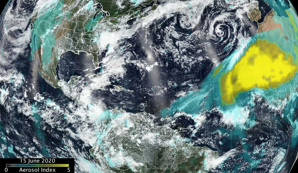
But the 2020 "Godzilla" storm was exceptional, becoming the Sahara's biggest and most concentrated dust cloud on record. It formed on June 13, reaching the Caribbean by June 22, Live Science previously reported. The dust cloud then arrived at the Gulf Coast on June 25, lending a hazy brownish tint to the skies and causing air quality alerts (as well as spectacular sunsets) in multiple states.
In some regions, the cloud carried about 70% more dust than the average storm, with plumes extending more than 5,000 miles (8,000 kilometers) across the Atlantic and toward the Caribbean and the southern U.S., the scientists reported in a study, published Dec. 1 in the journal Geophysical Research Letters.

The high-pressure system that energized and fed the dust storm also intensified the African Easterly Jet — a jet stream over the Sahara — "which rapidly transported the dust towards the Caribbean and southern United States," lead study author Diana Francis, lead author Diana Francis, a senior research scientist at the Khalifa University of Science and Technology in the United Arab Emirates, said in a statement.
Arctic sea-ice cover was also exceptionally low in June 2020, "around the lowest on record in the period of satellite observations," the researchers reported in the study. This could have shaped a large-scale anomaly in which Arctic winds dipped farther south than they normally do, potentially disrupting other wind patterns and leading to the formation of the high-pressure system and persistent northeasterly winds that birthed Godzilla.
"If such patterns become more common in a warmer world, it is plausible that these extreme dust outbreaks will increase in frequency in the future," the scientists wrote in their paper.
Prior studies have also shown that when dense dust clouds hover over the Atlantic, they can suppress tropical cyclones by cooling ocean waters. But surprisingly, June's monster dust storm was followed by one of the most active hurricane seasons on record, said study co-author Amato Evan, an associate professor at Scripps Institution of Oceanography, Climate, Atmospheric Science and Physical Oceanography at the University of California, San Diego.
"Either 2020 is just a year where everything is upside-down, or we really need to reevaluate our understanding of how dust impacts that climate system," Evans said in the statement.
Originally published on Live Science.