It's quick and easy to access Live Science Plus, simply enter your email below. We'll send you a confirmation and sign you up for our daily newsletter, keeping you up to date with the latest science news.
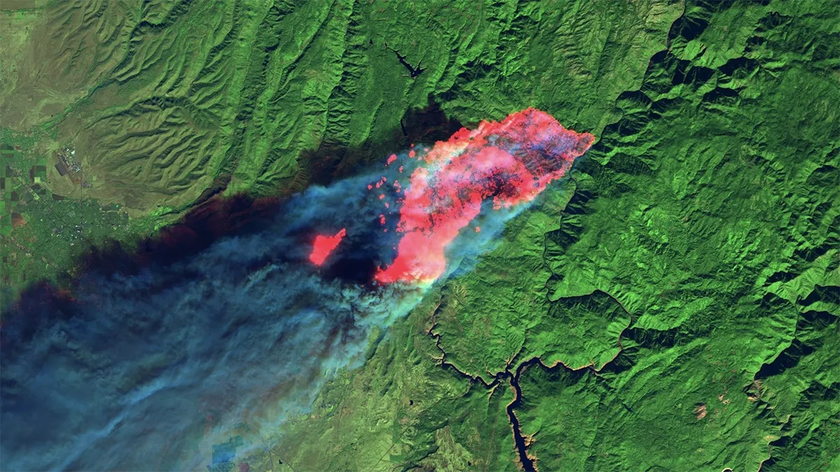
This satellite image, captured on Nov. 8, 2018, by Landsat 8, shows short-wave infrared (red), which gives the full extent of the actively burning area of the Camp Fire, just four hours after it started. The red patches are fires that leapfrogged in front of the primary burn front.
(Image credit: Earth Engine image by Jeff Chambers)
At least 66 people are dead and more than 600 missing after California's Camp Fire destroyed the town of Paradise on Nov. 8.
Now, a new satellite view shows the beginning of the horror. The imagery, quilted together by University of California, Berkeley, geographer Jeff Chambers, shows the fire just 4 hours after it ignited. The fast-moving blaze had already burned half of Paradise when the images were taken.
The Landsat-8 satellite happened to be orbiting over northern California at 10:45 a.m. local time on Nov. 8. The fire, which began around 6:30 a.m., is visible in infrared — which captures the heat of the flames — as a red blur spilling over the landscape. [See Photos of the Deadly Camp Fire]
"It's astonishing," Chambers said in a statement. "You can see the fire burning right through the city."
The satellite's visible-light images captured other views, these showing the billowing gray smoke. They give a sense of the fire's scope, but they obscure the location of the actual flames. The infrared data revealed how the fire moved through the buildings of Paradise, Chambers said.
A visible-light version of the Landsat-8 image from Nov. 8, providing a view of the gray smoke billowing from the Camp Fire.
(Image credit: Earth Engine image by Jeff Chambers)
"At 10:45 in the morning, all these structures were engulfed in flames," he said. "You can see that clearly in the image and start counting the hundreds of homes burned."
The data suggests that the fire was chewing up territory at a rate of about 3 mph (5 km/h) during the first 4 hours, Chambers found. It was not a predictable march: Flying embers from ignited spots shot far ahead of the advancing front. Survivors who fled the flames reported that they'd break free of one burning area, only to hit additional lines of fire in their paths.
Sign up for the Live Science daily newsletter now
Get the world’s most fascinating discoveries delivered straight to your inbox.
The Camp Fire has burned more structures than any wildfire in California history and has incinerated 142,00 acres, according to Cal Fire. As of 7 a.m. local time on Nov. 16, the fire was 45 percent contained, with more than 5,500 personnel working to mitigate the disaster.
Stephanie Pappas is a contributing writer for Live Science, covering topics ranging from geoscience to archaeology to the human brain and behavior. She was previously a senior writer for Live Science but is now a freelancer based in Denver, Colorado, and regularly contributes to Scientific American and The Monitor, the monthly magazine of the American Psychological Association. Stephanie received a bachelor's degree in psychology from the University of South Carolina and a graduate certificate in science communication from the University of California, Santa Cruz.

 Live Science Plus