













Mayday! 22 mysterious shipwrecks you can see on Google Earth
Google Earth has captured images of rotting and rusting hulls that are wasting away in shallow waters the world over.

The world's most famous shipwreck may be the RMS Titanic, but the remains of the luxury steamship are visible only to people in deep-sea submersibles and those watching feeds from remotely operated vehicles (ROVs).
But countless other shipwrecks are much more accessible, so long as you have Google Earth. This worldwide map has captured images of rotting and rusting hulls wasting away in shallow waters the world over.
Here are 22 mysterious shipwrecks you can see on Google Earth that have yet to be fully salvaged or worn away by the elements.
SS City of Adelaide

The steamship SS City of Adelaide is wrecked off the coast of Magnetic Island in Queensland, Australia. Built in 1864 in Glasgow, the 253-foot-long (77 meters) vessel was a passenger ship for many years before it became a coal storage vessel in 1902, according to Magnetic Community News. In 1912, its coal caught fire and part of the vessel went up in flames. Later, a Magnetic Island businessperson bought the ship with plans to make it into a tourist attraction or breakwater against the waves. But in 1916, the SS City of Adelaide met another disaster: During transport, it ran aground in Cockle Bay, where it remains today.
At low tide, it's possible to wade out to the ship. Sometimes, locals collect oysters that grow on its sides.
MV Captayannis

On Jan. 27, 1974, fierce winds hit the merchant vessel MV Captayannis, also known as the "Sugar Boat," while it was moored in Scotland's River Clyde, according to the BBC. The Greek-registered vessel was carrying raw sugar from East Africa to a refinery in Greenock at the time. The 60 mph (96.5 km/h) winds dragged the ship's anchor, and the Captayannis started drifting. The crew fired up its engines, but the boat ran straight into a BP tanker's anchor chains. The collision ripped a hole in the MV Captayannis' hull.
The crew managed to steer the sinking MV Captayannis into a sandbar, where it became stuck and tilted on its side, the BBC reported. It still sits there today; looters have stripped some of its materials, but the wreck doesn't interfere with other ship traffic, so it's been left to rust.
Get the world’s most fascinating discoveries delivered straight to your inbox.
MV Plassy

The MV Plassy, built in 1941, was the first motor vessel owned by Limerick Steamship Company Limited, whose boats mainly traded between ports in Ireland and continental Europe, according to the National Maritime Museum of Ireland. However, the Plassy was a "tramp ship" and went wherever its cargo took it, including South Africa, Greece and Russia, carrying chilled items such as fruit and fish. But a local voyage, from Fenit to Galway, proved its last.
In the early morning of March 1960, strong winds and heavy squalls of rain blew the Plassy ashore at Finnis Rock, which tore a hole in the vessel's bottom. "Next thing, Wallop, such a thump. We hit it so hard," said crewmember Eddie Reidy, according to the museum. "I was taken off the deck and hit the ceiling. Water started to rush in from underneath. There was shouting and running in all directions."
The ship lost power, and the crew abandoned ship. They were helped by locals who rushed out to rescue them. The ship was unsalvageable, but the crew got jobs elsewhere. The ship's remains are still at Finnis Rock.
Shale Scow

The 100-foot-long (30 m) Shale Scow — a flat-bottomed boat — sank in 1903 while tied to a dock in Elk Rapids, Michigan, according to Michigan Underwater Preserves. Because the boat sank in just 12 feet (3.6 m) of water, it's a popular site among snorkelers.
SS Benwood

The Norwegian steamship SS Benwood was armed to the gills during World War II. Built in England in 1910, the 360-foot-long (110 m) vessel was registered as a merchant marine freighter at the time it sank in 1942, but because of the U-boat threat, it was carrying 12 rifles, a 4-inch (10 cm) gun, six depth charges and 36 bombs, according to the Florida Keys National Marine Sanctuary.
However, a U-boat didn't sink it — rumors of one did.
On April 9, 1942, the Benwood was traveling from Tampa, Florida to Norfolk, Virginia carrying a cargo of phosphate rock. That night, the crew heard rumors a German U-boat was in the area, so they turned off the lights to stay out of sight. Another steamship, the Robert C. Tuttle was heading the opposite direction and didn't see the Benwood until the two crashed in the dark.
The Tuttle was larger and newer and wasn't in immediate danger, but the Benwood began taking on water, the Florida Keys National Marine Sanctuary reported. So the captain told the crew to abandon ship.
The shipwreck wasn't a total loss. The U.S. Army used it for aerial target practice after World War II and salvage missions recovered some of its materials. Nowadays, it's a popular dive site in the sanctuary.
Altair off Brazil

This wrecked ship — known as the Altair — is wasting away on the coast of southern Brazil, just south of the Rio Grande. A strong storm sank it in the winter of 1976, and it was later abandoned and looted, according to the Municipal Prefecture of Rio Grande.
The ship is now the habitat for many species, and the beach is well known for fishing and nautical sports, including surfing. Tourists visiting the boat can also see sand dunes, waterfalls and wild animals, including black seagulls, tortoises and hawks.
Capsized in Iraq

This giant vessel met disaster in Basra, Iraq. It capsized in the Shatt al-Arab, also known as the Arvand Rud, a river that runs through southern Iraq and forms the border between Iran and Iraq near the Persian Gulf. The river formed where the Tigris and Euphrates rivers come together at Qurna, which some people reportedly believe is the site of the biblical Garden of Eden, according to The National, an online news agency in the Middle East.
The river seems to be a graveyard of sorts: According to estimates by the General Company of Ports of Iraq (GCPI), around 36 sunken ships lie in the Shatt al-Arab, according to niqash.org.
USS Utah

Japanese B5N2 Kate torpedo bombers sank the USS Utah during the Pearl Harbor attack on Dec. 7, 1941. The attack killed 64 crewmen, 58 of whom were entombed in the ship when it capsized, according to the Pacific Aviation Museum in Hawaii.
The USS Utah, a dreadnought battleship, was not an active battleship, but rather an auxiliary ship, when the Japanese bombed it. The Japanese knew this, but one pilot thought it was an active battleship and bombed it by mistake, as did one of his wingmen. Their superiors were furious because the bombers had just 40 torpedoes, and it was a large loss to mistakenly use two, according to the museum.
SS Maheno

During World War I, New Zealand converted this passenger ship — the SS Maheno — into a floating hospital, according to New Zealand History.
After the war, the SS Maheno became a passenger ship again, and was later sold to an Osaka ship-breaker company for scrap metal in 1935. But the ship never made it there: A cyclone severed the towline connected with the SS Maheno and the Oonah, the ship towing it, according to Atlas Obscura. Three days later, the Maheno and its small crew were found stranded on the beach of Fraser Island, off the coast of Queensland, Australia.
Staten Island boat graveyard

"An accidental marine museum," as one nautical magazine calls it, this boat graveyard on the shores of southern Staten Island, New York, was founded in the 1930s by John J. Witte (who died in 1980), the The New York Times reported; Witte reportedly would not dismantle any of the ships unless he had a buyer, according to The New York Times. Thus, they continued to accumulate. But soon, the Witte Marine Equipment Co. had more boats than it could disassemble, according to Forgotten New York. Some dated to before World War I, the New York Times reported in 1990.
Since then, the wrecks have become a habitat for underwater marine life. Environmental laws now mandate that the hundreds of hulls stay untouched at the site, which is now known as the Donjon Recycling.
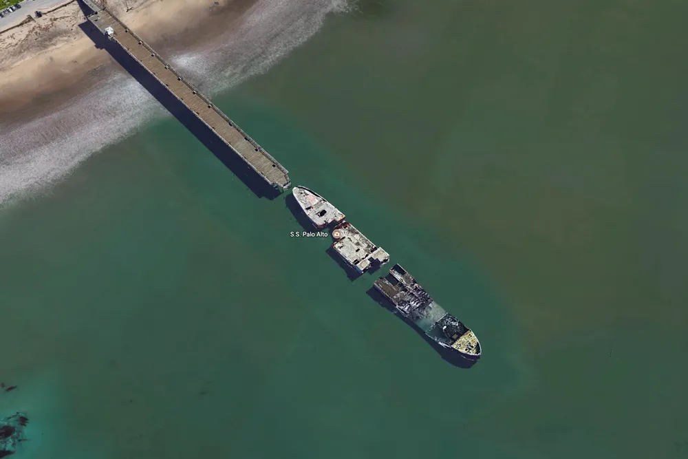
SS Palo Alto
This famous concrete tanker was made to fight the Central Powers during World War I, but the war ended before it could enter battle.
Why was it made out of concrete? During the war, there were concerns about steel shortages. So, the Emergency Fleet Corporation, formed under President Woodrow Wilson, requested 24 new ships be built out of ferroconcrete and reinforced with steel, according to The Washington Post.
After it was made in Oakland, California, the SS Palo Alto was moved south to Aptos, California, by the Cal-Nevada Company in 1929. In 1930, a pier was constructed to reach the boat, and it became a popular tourist destination, as well as an environmental hazard that was finally cleaned up in 2006.
The ship continues to weather damage. In January 2017, a storm off the coast of California ripped the stern off the SS Palo Alto.
SS Francisco Morazan

The SS Francisco Morazan sits at the Bottom of Lake Michigan, after it ran aground during a wild snowstorm in 1960.
The Holland-bound ship left Chicago on Nov. 27, 1960, with 940 tons of cargo, according to the National Park Service. But the next day, 40 mph (64 km/h) winds brought water on board the ship. Blinded by snow and heavy fog, the crew mistakenly ran the ship aground by South Manitou Island.
The crew abandoned the ship, and because the ship's owners never came forward, the ship was left in the lake, where it is now home to birds, including cormorants and gulls.
Half Moon schooner-yacht

The Half Moon Underwater Archaeological Preserve is the watery grave for a German 366-ton steel schooner-yacht with two masts. The 1908 vessel once sported the name Germania and sped through the water as a racing yacht, according to Florida's Museums in the Sea.
However, Germania was seized by England during World War I, and it was later sold and renamed the Half Moon. Then, it sailed down to Miami, where it was repurposed as a floating cabaret during the Prohibition era.
The schooner-yacht sank in 1930, when a storm ran it aground, according to DiveSpots.com. The Half Moon is now visited by snorkelers and divers visiting the archaeological preserve.
Abandoned in Argentina

The St. Christopher will likely sit the rest of its days in the harbor of Ushuaia in southern Argentina.
The vessel is an American-built rescue tug that served in the British Royal Navy during World War II, as part of the Lend-Lease Act, according to NavSource Online. The Royal Navy decommissioned the tug after the war, and sold it in 1947 to a man in Buenos Aires, Argentina. He chartered it for salvage operations, but it ran into engine trouble and rudder damage in Beagle Channel by Ushuaia.
The St. Christopher ran ashore and was abandoned in 1957, and photographers have snapped photos of the deteriorating tug ever since. To prevent environmental disaster, its remaining fuel was drained in 2004, according to NavSource Online.
Skeleton Coast shipwreck

This rusty shipwreck sits on the Skeleton Coast, just north of Luderitz in Namibia.
The 976-mile-long (1,570 kilometers) Skeleton Coast is littered with shipwrecks, according to the HuffPost. That's because when the Atlantic's cold currents mix with the dry, warm air from the Namib Desert, the two create a cold, dense fog that can befuddle even careful ship captains, the HuffPost reported.
The Khoisan Bushmen, a tribe of hunter-gatherers, apparently call the Skeleton Coast "the land God created in anger," according to Tahir Shah in a BBC article, in which he described the land as being littered with "huge bleached whalebones, the crumbling hulks of shipwrecks, dead plants, and the footprints of infrequent desert creatures, all on a desperate search for sustenance."
MS World Discoverer

The MS World Discoverer sits just off the shore of one of the Solomon Islands in the Pacific Ocean.
The Danish cruise ship was constructed in 1974 and met disaster after striking a rock during a cruise in 2000, according to the History channel. The crew sent out a distress signal and arranged for all of the passengers to be safely escorted to a passenger ferry.
But the ship's journey wasn't complete. It was looted and damaged during the Solomon Islands Civil War. It still sits at Roderick Bay, where tourists photograph the tropical vegetation growing on its deck.
Breakwater boat

The Point San Pablo Yacht Harbor in Richmond, California, contains a sunken vessel that was purposefully placed there as a breakwater — a barrier that protects the harbor from San Francisco Bay's never-ending waves.
Capt. Raymond H. Clark, who started the marina, couldn't afford a breakwater levee, so he came up with the unconventional idea of using sunken ships, according to Point San Pablo Yacht Harbor. He got his hands on condemned wooden schooners and towed them to the best position for the marina.
"This graveyard of coastal steamers was quite picturesque," especially for people fishing for striped bass, which were abundant in the area, Harbor's website said.
Oakland treasure

The waters around Oakland and San Francisco are filled with rotting shipwrecks. This one sits in San Leandro Bay, not too far from the Oakland International Airport.
Thames River wrecks

These moldering boats sit in the Thames River, just off the United States Coast Guard Academy in New London, Connecticut.
Disaster in Greenland

This shipwreck is wasting away off the southwest coast of Nuuk, Greenland.
Ship skeleton off Cape Cod

The outline of a shipwreck can still be seen on Cape Cod's Long Point.
Wrecked in Baja California Sur

This enormous vessel washed ashore on a beach in Mexico's Baja California Sur.
Editor's note: This countdown was originally published on Sept. 24, 2017 and updated on Aug. 20, 2024 to include more shipwrecks.

Laura is the managing editor at Live Science. She also runs the archaeology section and the Life's Little Mysteries series. Her work has appeared in The New York Times, Scholastic, Popular Science and Spectrum, a site on autism research. She has won multiple awards from the Society of Professional Journalists and the Washington Newspaper Publishers Association for her reporting at a weekly newspaper near Seattle. Laura holds a bachelor's degree in English literature and psychology from Washington University in St. Louis and a master's degree in science writing from NYU.