


Amazing Snapshot: Jet Zooms Over Bahamas in Astronaut Photo
The turquoise waters snaking through Great Exuma Island in the Bahamas are almost unbelievably vivid in a new photograph taken from space.
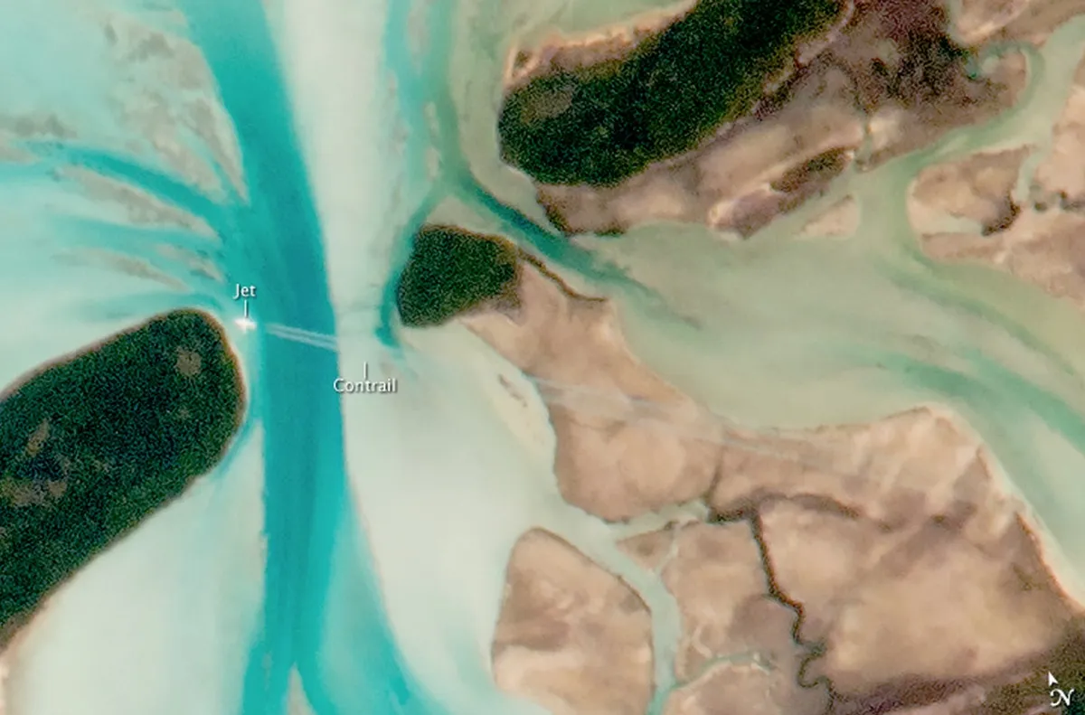
But zoom in, and the picture becomes even more impressive.
An astronaut with a long lens and a steady hand captured not only the natural tidal channels cutting through the small islands of the Bahamas, but also a jet and its two contrails cutting across one of the channels.

The image was acquired July 15, 2015, according to NASA's Earth Observatory. The Bahamas and their prominent tidal channels are recognizable landmarks for astronauts aboard the International Space Station, who whiz by about 249 miles (400 kilometers) overhead. [See Photos of Streaming Contrails from High-Flying Jets]
Great Exuma Island is one of the bigger isles among a string of small cays in the Bahamas, many of which are private playgrounds for the fantastically wealthy. Great Exuma is about 37 miles (59 km) long. It's part of a string of 365 cays, some privately owned.

The cays were a haven for British Loyalists who fled the United States after the American Revolution. One prominent Exuma landowner, the Englishman John Rolle, left his property there to his slaves. His name is still prominent on the islands, both as a surname and as the name of towns such as Rolleville.
The cays are also home to natural beauty, not limited to clear blue waters and sparkling white beaches. Moriah Harbour Cay National Park protects 16,800 acres of sand dunes, seagrasses and mangroves, according to the Bahamas National Trust. The area is an important ecosystem for nesting birds.
Get the world’s most fascinating discoveries delivered straight to your inbox.
At "pig beach" on Big Major Cay, a mysterious colony of domesticated pigs plies the water, begging food from tourist boats. No one knows how pigs came to live on the otherwise uninhabited island; a shipwreck or sailors dropping off the pigs as a sort of living food bank for later trips might be the cause, according to the official website of the Bahamas. The swimming pigs are now a major tourist draw.
The cays are also home to a much older form of life. Stromatolites, lumpy rocklike structures created by microbial mats, still thrive here, particularly off the coast of Lee Stocking Island. Stromatolites are some of the oldest forms of life on Earth, dating back 3.5 billion years.
From space, the tidal rhythms of life are visible. In this image, about 8.9 miles (14.24 km) of cays are visible, with deep, blue channels cutting through them. The darker the water, the deeper it is; light blue represents water less than 80 feet (25 m) deep, according to Earth Observatory. The jet cuts across the largest channel in the upper right corner of the photograph.
Follow Stephanie Pappas on Twitterand Google+. Follow us @livescience, Facebook& Google+. Original article on Live Science.

Stephanie Pappas is a contributing writer for Live Science, covering topics ranging from geoscience to archaeology to the human brain and behavior. She was previously a senior writer for Live Science but is now a freelancer based in Denver, Colorado, and regularly contributes to Scientific American and The Monitor, the monthly magazine of the American Psychological Association. Stephanie received a bachelor's degree in psychology from the University of South Carolina and a graduate certificate in science communication from the University of California, Santa Cruz.