


Greenland's Hidden Ice Layers Revealed in New Map
Layer by layer, scientists have filled in a new map of the hidden expanses of Greenland's vast ice sheet, revealing where the island hides its oldest ice.
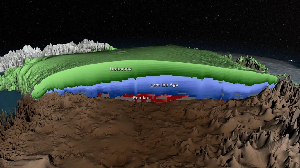
The 3D map reveals where areas of ice of different ages are located across the frozen island. The research team built the 3D map of Greenland's ice sheet using data from airborne radar and ice cores. Radar measurements revealed the ice's thickness, and was also used to find internal layers concealed under the surface. The ice cores provided precisely dated ages for these different layers at various points around the island. (The oldest ice found so far in Greenland's ice cores is about 130,000 years old.) Like playing a giant game of connect the dots, the team drew in the map by linking the ice cores with the internal layers detected by airborne radar.
The researchers have divided the map into Holocene-period ice (the last 11,700 years), ice from the Ice Age (from 11,700 to 115,000 years ago) and ice from the Eemian Period (115,000 to 130,000 years ago.) [Watch: Greenland Ice in 3D Reveals 3 Distinct Climate Periods]
The biggest surprise revealed by the new map is that more ice from the Eemian Period ice is in central northern Greenland than scientists knew existed, said lead study author Joe MacGregor, a glaciologist at the University of Texas at Austin Institute for Geophysics. "Figuring out where this Eemian ice might be has been a challenge," MacGregor told Live Science. "It would be great to get more of it [through drilling], so we can understand what the Eemian was like."
Researchers are particularly interested in hunting for Eemian Period ice because it contains clues to how the ice sheet will respond as the planet warms today. The Eemian Period was Earth's most recent warm spell, when the planet was as warm as it is becoming now. During this older warming period, Greenland kept some of its ice. After the Eemian, the planet's climate entered a long ice age, during which modern humans evolved. "The climate changes that are occurring today are happening a lot faster than in the Eemian, but if we can understand what the Eemian was like, than we can understand where [today's] climate is going," MacGregor said.
This is the first time anyone has assembled a stratigraphic map, one that shows all of the layers of Greenland's ice sheet, the scientists said. The results were published January 16 in the Journal of Geophysical Research: Earth Surface.
"It was a challenging problem and a daunting one, because there was a lot of data," MacGregor said. "It had kind of become like cleaning out your garage after 10 years of ignoring it. You know you might find something very exciting, but you have to go through the pain of cleaning it."
Get the world’s most fascinating discoveries delivered straight to your inbox.
The new map will serve as the keystone for several planned research projects, MacGregor said. For instance, the structure of the ice layers can be used to study how fast the ice sheet flows and where it's melting. Digging into the history of the ice will also reveal more about how it formed and help predict the future of the ice sheet as the climate warms, he added.
Follow Becky Oskin @beckyoskin. Follow Live Science @livescience, Facebook & Google+. Originally published on Live Science .
