It's quick and easy to access Live Science Plus, simply enter your email below. We'll send you a confirmation and sign you up for our daily newsletter, keeping you up to date with the latest science news.
The hot, wrinkled lava from Iceland's Bardarbunga volcano shines bright in two new satellite images of the blazing eruption.
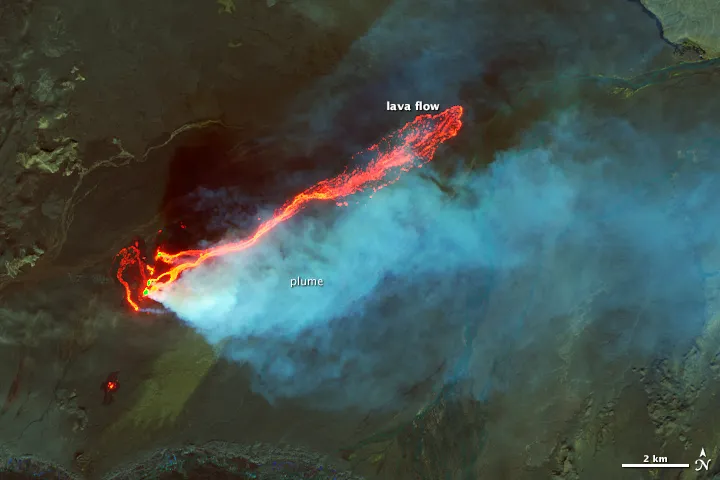
Runny basalt lava has streamed across the stark landscape of the Holuhraun lava field since the Aug. 28 volcanic eruption blasted open a long crack north of Bardarbunga volcano. The rumpled rock now blankets nearly 8 square miles (20 square kilometers) — roughly the area from Manhattan's Times Square south to Battery Park.
Holuhraun's black sands and glacier-fed river channels are lit by the glow of lava fountains leaping more than 300 feet (90 meters) into the air in a false color image snapped Sept. 6 by NASA's Landsat 8 satellite. The Landsat photo seen here combines shortwave infrared, near-infrared and green light. [Images: Iceland's Blazing Volcano Seen From Space ]
Ice, steam and volcanic gas appear bright blue in the image. Dyngjujokull glacier fills the bottom left corner of the image, and a sulfur dioxide gas plume wafts to the right. The noxious gas has spawned toxic volcano tornadoes and drifted as far as Norway and Greenland.
Iceland's Holuhraun eruption seen in a combined before-and-after radar image from the TerraSAR-X satellite.
(Image credit: German Aerospace Center)
The latest addition to Iceland's landscape also stands out in a combined before-and-after radar image from the TerraSAR-X satellite, operated by the German Aerospace Center. The separate images, shot on Aug. 13 and Sept. 4, reveal differences in the Earth's surface. The rough lava surface stands out in the lower right corner. Askja volcano and its crater lake are in the lower center.
The lava flow continues to advance by about 0.6 miles (1 km) per day, according to the Icelandic Met Office. The agency's scientific advisory board said the eruption would likely follow one of three scenarios. These are listed in order of impact, not in the order of probability:
The eruption stops.
Lava flows from the Holuhraun crack (also called a fissure) for months to years. In Hawaii, a fissure eruption in Kilauea volcano's East Rift Zone is still going after three decades
Bardarbunga volcano blows. The Holuhraun eruption is about 20 miles (32 km) northeast of the central volcano. But Bardarbunga's caldera (a bowl-shaped depression) has sunk 65 feet (20 m) and magnitude-4 and -5 earthquakes continue to rock the volcano.
Becky Oskin covers Earth science, climate change and space, as well as general science topics. Becky was a science reporter at Live Science and The Pasadena Star-News; she has freelanced for New Scientist and the American Institute of Physics. She earned a master's degree in geology from Caltech, a bachelor's degree from Washington State University, and a graduate certificate in science writing from the University of California, Santa Cruz.

 Live Science Plus