
 Live Science Plus


Amazing Maps Made by Founder of 1st U.S. Settlement

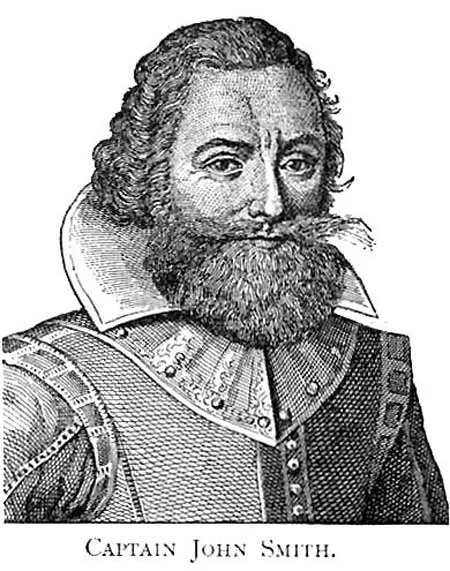
Maybe Pocahontas had a thing for men with superior mapping skills. Captain John Smith, the famous founder of America's first settlement, at Jamestown, Virginia, traced the Chesapeake Bay river system with remarkable precision from his primitive sailboat, geographers have discovered. Using a sophisticated "remapping" system that merges old maps with the modern lay of the land, the team from Maryland's Salisbury University found that Smith's 1608 exploratory charting of the Chesapeake was well ahead of its time considering the tools he had to work with. “It’s amazing, he mapped with a stunning level of accuracy,” said team leader and geoscientist Michael Scott. “He’s out there in this little boat navigating the hazards of uncharted territory and he was able to capture most major bends of the rivers and everything is pretty close to scale. His map was so accurate that it was used as the prototype of the bay for more than 100 years.” Smith sailed into Virginia's Chesapeake Bay in the summer of 1608, just a few months after Pocahontas saved him from death at the hands of her father, according to legend. For more than three months and 1,700 miles, Smith relied on a simple—though likely quite boring—geometric process to chart the twists and turns of Chesapeake offshoots such as the Nanticoke River, Scott said. "Smith had a compass and a chip log (a way to measure a boat's speed through the water). He performed a process similar to dead reckoning. He would take a bearing from a couple of points on shore, thus creating an angle. Then he would sail in a given direction of one of the points, measuring distance," Scott told LiveScience. "Once you've got one length, you take bearings and angles all the way up the river." The explorer was able to make his drawings so accurate with some old-fashioned, meticulous double-checking, Scott speculated. "My guess is he was just careful and measured the same area a few times, perhaps up and back. If we had his log/notes, we'd really be able to tell," said Scott, "[but] those are probably buried in some attic in England." A crew of historians, teachers and geographers recently set sail in a reproduction of Smith's shallopboat to commemorate the 400th anniversary of his voyage. During the 121-day journey, they'll stop at old Native American settlements and other important points along the shore to give public exhibitions and lectures.
Get the world’s most fascinating discoveries delivered straight to your inbox.
