


Irish Whodunit: The Mystery of the Moving Boulders
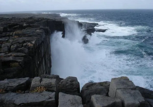
On a trio of tiny islands off Ireland's western coast, there is a mystery afoot. Something has picked up massive boulders and set them down inland, on a flat, wind-lashed landscape encircled by craggy cliffs that rise from the Atlantic Ocean.
Strewn along the haunting, rugged coastlines of the Aran Islands, the rocks were ripped from the faces of the surrounding cliffs below. Some originate from beneath the ocean's surface. The largest of these boulders weigh about 78 tons, and lie some 40 feet (12 meters) above the reach of the sea. Smaller boulders, weighing about 3 or 4 tons each, lie more than 820 feet (250 m) inland.
"The local people say that these rocks are moving ," said geologist Ronadh Cox, a professor of geosciences and chairwoman of the maritime studies program at Williams College in Massachusetts.
So what unseen hand is capable of tossing such heavy boulders so far inland?
Cox said that she and some of her students have uncovered the answer, thanks to some man-made rock walls, some high-tech tools, a species of tiny clam, and maps made more than a century ago. The team presented work at the recent Geological Society of America annual meeting held in Minneapolis, and have submitted the research for publication.

Tsunamis or storms?
Scientists have long thought that huge waves moved the boulders, but there's disagreement about the source of those waves: powerful storms or tsunamis? Cox said the evidence points to powerful storms — and that collaring the appropriate watery culprit is important for scientists studying the source and mechanisms of tsunamis.
Get the world’s most fascinating discoveries delivered straight to your inbox.
"There is a real need to try and understand the process by which boulder deposits can form," Cox told OurAmazingPlanet. "The reason the Aran Island deposits are so key, is it's one of the few places you have these boulder deposits where there is no recent tsunami history."
A tsunami hasn't hit the region since 1755, when a magnitude 8.7 earthquake near Lisbon destroyed much of the Portuguese capital, and sent damaging waves crashing ashore in Europe and Africa. [Related: The 10 Biggest Earthquakes in History]
As far north as the Aran Islands of Inishmore, Inishmaan and Inisheer, the tsunami was relatively small, and likely didn't have a huge effect. Ancient tsunamis many hundreds, if not thousands, of years earlier could play a role, Cox said.
However, if some of the largest rocks have moved since 1755, powerful storms are likely heaving them ashore. If not, tsunamis are a likely culprit.
Previous research has come down on both sides of the debate, and Cox's team set out to add to the body of work.
The team dated the shells of fingernail-size Hiatella arctica clams — a species that digs deep burrows into ocean rocks — whose teeny remains they retrieved from holes bored into some of the smaller Irish boulders that weigh several tons each.
Their research, combined with previous studies of the clam shells, indicated the rocks had been out of the water for varying times. Some arrived on land 2,000 years ago, but others arrived less than 50 years ago, indicating that storm waves must have deposited rocks that showed up after 1755.

Which wave?
However, Cox said, it is the largest boulders, which weigh many dozens of tons, that are the most important factor in the hunt for the waves that moved them. The greatest help in the search came from an unlikely source: a long-dead team of meticulous British surveyors, who mapped the islands in painstaking detail more than 150 years ago.
The Williams College team loaded British survey maps made in 1839 into a database, and lined up the old images with modern-day aerial measurements, using rock walls built by farmers over the course of hundreds of years as a comparison point.
"Where the walls still exist, they line up exactly, so we know that this was a very accurate map. Those guys were not off by even 10 centimeters. It's unbelievable," Cox said.
Since the Victorian mappers included the boulders in their survey, the team could see how much they'd moved.
"In some cases there's almost no change, and there are other places where the boulder ridge has overridden the walls and is sitting 30 meters [100 feet] inland of where it was sitting in 1839," Cox said.
In addition, some of the largest boulders now sit directly atop areas where the 19th-century maps indicate a wall once stood — a key piece of evidence that leaves powerful storm waves holding the smoking gun, Cox said.
Doing the wave
Accurately assessing the footprint of tsunamis — both contemporary and ancient — is important for scientists seeking to model and predict their source, and understand the forces at work in the waves themselves, according to Vasily Titov, head of the National Oceanic and Atmospheric Administration's Center for Tsunami Research, and architect of one of the most widely used tsunami models today.
"Models are great tools, but they're only as good as the data that are put into them. If the data coming into the model are wrong, then the model is wrong," Titov said.
Titov said that when building tsunami models , researchers often work backwards, and, by looking at the evidence tsunamis have left behind on land, can better pinpoint faults beneath the seafloor that produced the earthquakes that generated the waves.
Titov said that, along with boulders, sand and other kinds of sediment are dumped onshore by both tsunamis and storm waves, and that parsing which event is responsible is very difficult, but a worthy pursuit. Because large tsunamis are, on the vast scope of geological time, fairly rare, modelers need all the data they can get, Titov told OurAmazingPlanet.
"Boulders are only a small part of the puzzle, but they're an important part," Titov said.
"The boulder can tell you something about the force and the height of the wave, so you can backtrack with that information offshore, and ask, 'What kind of wave can do that?'" he said.

Wandering rocks
The people who live on the Aran Islands have witnessed the handiwork of such waves firsthand. Cox described an encounter with a local man who, when he learned of her research, pointed out a massive boulder that appeared overnight, after a furious winter storm in 1991.
Cox hunted through Irish government weather data and found that in the winter of 1991, a particularly ferocious storm hit the area. "And — I think this is important — that particular rock is sitting exactly on the location of a 19th-century field wall," Cox said.
"You can choose to believe or not believe the anecdotal evidence, but we can back it up," Cox said. "The point is there was no tsunami in that time interval. It doesn't matter if it moved in 1891 or 1991, the point is there was no tsunami."
Cox said even during her field work, always done in the summer months, when the sea is more peaceful than in winter, the ocean's power is astonishing. [Related: The World's Biggest Oceans and Seas ]
"The waves can just climb these cliffs in amazing ways," she said.
- 7 Ways the Earth Changes in the Blink of an Eye
- Top 10 Ways Weather Changed History
- World's Most Famous Rocks
You can follow OurAmazingPlanet staff writer Andrea Mustain on Twitter: @andreamustain. Follow OurAmazingPlanet for the latest in Earth science and exploration news on Twitter @OAPlanet and on Facebook.