Our amazing planet.

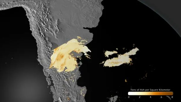
Chile Volcano Ash Plume Tracked Over Atlantic

chile-volcanic-ash-110615-02
(Image credit: NOAA)

A 1,350 km ash plume can be seen extending from the Puyehue-Cordon Caulle volcano in Chile eastward over the Atlantic in this NASA Aqua MODIS satellite image acquired on June 13, 2011. The northern edge of the plume over Argentina is cut-off due to the orbit of the satellite and data availability.

Volcanic ash poses a significant threat to air traffic as jet engines may stall if excessive amounts of ash are ingested. NOAA's Volcanic Ash Advisory Center uses a variety of satellite measurements and models to provide guidance to the FAA in order to properly re-route traffic away from areas impacted by volcanic ash.

In preparation for the launch of the NOAA GOES-R satellite in 2015, NOAA scientists at the cooperative research institute at the University of Wisconsin have developed equations that can be used to calculate the amount of ash within the plume. GOES-R will greatly advance volcanic ash monitoring: its resolution will be comparable to the MODIS imagery seen here, but with the added benefit of being acquired every 5 minutes, instead of only twice a day, as is the case for MODIS. This greater frequency of data will allow NOAA to more accurately predict where the ash plumes will travel.

Live Science Staff
For the science geek in everyone, Live Science offers a fascinating window into the natural and technological world, delivering comprehensive and compelling news and analysis on everything from dinosaur discoveries, archaeological finds and amazing animals to health, innovation and wearable technology. We aim to empower and inspire our readers with the tools needed to understand the world and appreciate its everyday awe.