Our amazing planet.

Missouri Floods Setting Records

missouri-flooding-611-110613-02
(Image credit: NASA/GSFC)

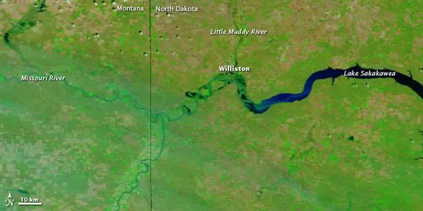
The Missouri River was at major flood stage near Williston, North Dakota, in early June 2011, according to a NASA statement. On June 13, 2011, the Advanced Hydrological Prediction Service (AHPS) of the U.S. National Weather Service reported that the Missouri River reached 29.29 feet (8.93 meters) near Williston at 3:30 a.m. local time. This was above the record level of 28.0 feet (8.5 meters) set in 1912, although the AHPS explained that gauge readings could be affected by backwater from the lake downstream.

The Moderate Resolution Imaging Spectroradiometer (MODIS) on NASA's Terra satellite captured these images on June 11, 2011 (top), and June 4, 2010 (bottom).

These images show the area around Williston, North Dakota, including the western part of Lake Sakakawea. In 2010, the Missouri River is a thin river meandering through a vegetation-lined valley south of Williston. A year later, the river fills the valley. Little Muddy River north of Williston also appears higher.

(Image credit: NASA/GSFC)
Live Science Staff
For the science geek in everyone, Live Science offers a fascinating window into the natural and technological world, delivering comprehensive and compelling news and analysis on everything from dinosaur discoveries, archaeological finds and amazing animals to health, innovation and wearable technology. We aim to empower and inspire our readers with the tools needed to understand the world and appreciate its everyday awe.