
 Live Science Plus


Ongoing Eruption of Tungurahua, Ecuador

published
(Image credit: Jesse Allen, NASA.)
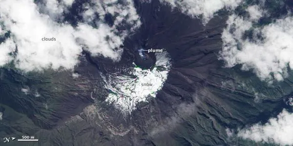
According to Ecuador's Instituto Geofisico, the Tungurahua volcano was active throughout the last weeks of 2010, with reports of ashfalls on towns near the volcano and explosions that sounded like cannons. Steam and ash plumes were observed rising as high as 36,000 feet (11 kilometers) above sea level.
These two images show Tungurahua as observed by the Advanced Land Imager (ALI) on NASA's Earth Observing-1 (EO-1) satellite on Jan. 1, 2011.


(Image credit: Jesse Allen, NASA.)
Tungurahua is one of the most active volcanoes in Ecuador. The last major eruption took place between 1916 and 1918, with minor activity for several years thereafter. The volcano's location is frequently cloudy, so clear satellite views of the volcano are not common.
- The World's Five Most Active Volcanoes
- Image Gallery: Volcanoes from Space
- Images: Journey to Kamchatka's Volcanoes
TOPICS
