It's quick and easy to access Live Science Plus, simply enter your email below. We'll send you a confirmation and sign you up for our daily newsletter, keeping you up to date with the latest science news.
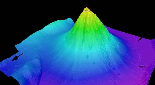
Perspective view of the Kawio Barat (West Kawio) seamount looking from the northwest. The underwater volcano rises around 10,000 feet (3,800 meters) from the seafloor.
A huge underwater volcano has been mapped and photographed by scientists exploring the deep ocean north of Sulawesi, Indonesia.
The more than 10,000-foot- (3,048-meter-) tall volcano is called Kawio Barat, referring to the ocean area west of Indonesia's Kawio Islands, south of the Philippines. The giant volcano was mapped by the U.S. National Oceanic and Atmospheric Administration (NOAA) ship Okeanos Explorer.
So far the ship has mapped 2,400 square miles (6,216 square kilometers) of the Indonesian seafloor, an area equal to the size of Delaware. The project is part of an ongoing mission to reveal the mysteries of the ocean floor.
"This is a huge undersea volcano, taller than all but three or four mountains in Indonesia, and rising more than 10,000 feet from the seafloor in water more than 18,000 feet (5,486 meters) deep," said microbiologist and team member Jim Holden of the University of Massachusetts in Amherst. "The more we understand these undersea features and the communities of life they support, the better we can manage and protect the ocean and its resources."
Barnacles covering sulphur structures on Kawio Barat volcano.
(Image credit: INDEX 2010.)
While many scientific expeditions brave extreme conditions , many team members were not actually on board Okeanos during the mapping mission. Some scientists worked from shore via satellite and high-speed Internet connections at command centers in Jakarta, Indonesia and Seattle, Wash.
Okeanos Explorer was equipped with sonar and an underwater robot, called a Remote Operating Vehicle (ROV), which is tethered to the ship and piloted by crew on board. The ROV can descend as deep as 13,000 feet (3,962 meters) and provides live video from the seafloor.
Little Hercules ROV descends down to the summit of the Kawio Barat submarine volcano.
(Image credit: INDEX 2010.)
In mid-July, the Indonesian research and fisheries vessel Baruna Jaya IV will map more of the seafloor and deploy instruments within the Kawio Islands before both ships meet in the Indonesian Port of Bitung. They will redeploy on July 21 to continue exploring more of the uncharted ocean near the island chains of Sangihe and Talaud. The expedition concludes on Aug. 14.
Sign up for the Live Science daily newsletter now
Get the world’s most fascinating discoveries delivered straight to your inbox.
Investigating previously unexplored ocean areas will yield new phenomena and provide information that will improve our understanding of ocean ecosystems, ocean acidification and climate change impacts, said the scientists.
"Ocean-related concerns, including food security and protecting ocean ecosystems that support fisheries, affect many nations including Indonesia a nation of 17,000 islands," said team member Sugiarta Wirasantosa of Indonesia's Agency for Marine and Fishery Research. "To understand and manage such things, we must first explore. That's why this expedition is so important."
Little Hercules ROV images a vent plume as it descends to the summit of Kawio Barat submarine volcano.
For the science geek in everyone, Live Science offers a fascinating window into the natural and technological world, delivering comprehensive and compelling news and analysis on everything from dinosaur discoveries, archaeological finds and amazing animals to health, innovation and wearable technology. We aim to empower and inspire our readers with the tools needed to understand the world and appreciate its everyday awe.