A recently installed FAA navigation system called the Wide Area Augmentation System (WAAS) is making life much easier for general-aviation pilots in the United States, particularly when trying to land at small airports in bad weather.
Pilots flying aircraft equipped with the latest Global Positioning System (GPS) equipment in the continental U.S. and much of Canada and Mexico are now able to pinpoint their location to within 25 feet, thanks to WAAS.
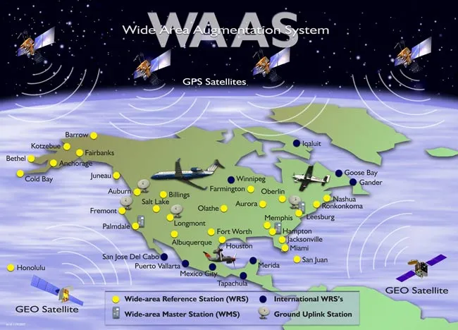
WAAS is a network of 39 precisely surveyed ground reference stations located across the U.S. and in parts of Canada and Mexico. The system also involves two master stations, one each on the west and east coasts, and three data uplink stations.
Latest Videos From
Ground reference stations in the WAAS network collect GPS satellite data and develop messages to correct any signal errors, which are caused by ionosphere disturbances and timing and satellite orbit errors.
These correction messages are broadcast through communication satellites to GPS receivers on aircraft, ships, and land vehicles equipped with a WAAS-GPS receiver. WAAS also provides GPS-satellite-integrity information to the U.S. Air Force 50th Space Wing, which manages the satellite constellation.
The Global Positioning System
The Global Positioning System comprises 31 satellites circling the earth at a medium orbit of approximately 12,660 miles. The satellites transmit signals to GPS receivers that have become common in aircraft, maritime vessels, and land vehicles. Certain types of cell phones and watches also have a GPS receiver.
Using the data transmitted via microwave signals from the satellites, GPS receivers determine their location, speed, and direction, and display the information to users. The satellite signal also includes the precise time.
Non-WAAS GPS receivers provide positional fixes accurate to within approximately 50 feet. In aircraft, such receivers do not provide vertical guidance to pilots flying instrument approaches.
But WAAS provides the additional accuracy, integrity, and availability required to navigate using GPS for all phases of flight, from enroute flying to instrument approaches at qualified airports within the WAAS coverage area.
Because of this, prominent aviation organizations such as the National Business Aviation Association and the Aircraft Owners and Pilots Association (AOPA) have been strong supporters of WAAS.
“We have urged both Congress and the FAA to press ahead with the program because it improves air safety by providing the precision vertical guidance needed, especially in poor weather conditions," said Phil Boyer, president of AOPA, in March 2006. "And it makes better use of the nation's system of airports, because thousands that currently may only be used in good weather can become all-weather capable.”
Lateral precision, vertical guidance
WAAS-GPS provides lateral precision, vertical guidance (LPV) down to 200 feet above runways using developed LPV instrument approaches. The advantage of WAAS to pilots is that they can fly an instrument approach in poor weather at many more airports than before, particularly at smaller, general aviation airports. As a result, WAAS improves the efficiency and capacity of the U.S. National Airspace System.
However, because some of the satellites that receive WAAS correction signals are over the equator, GPS-WAAS users in North America who are in mountainous areas may experience difficulty receiving the WAAS signal. Until more ground reference stations are installed, signal reception is best in open land and marine environments.
The FAA and Department of Transportation began developing WAAS in 1994. The system has been available for visual flight rules (VFR) and recreational use since August 2001. In July 2003, WAAS was approved for non-precision aircraft instrument operations, and in March 2006, LPV approaches became available. The WAAS project is expected to be completed in 2013, with a final price tag of $3.3 billion.
WAAS produces cost savings for FAA
It costs about $50,000 to map and publish a new, WAAS-GPS LPV approach. By comparison, a Category 1 instrument landing system (ILS), which is comprised of electronic equipment installed at an airport that guides aircraft horizontally and vertically down to 200 feet above a runway, costs from $1 million to $1.5 million per runway end.
FAA cost savings are another advantage of WAAS, which allows redundant ground-based navigation aids to be decommissioned. WAAS also provides a back-up capability in the event of an ILS outage.
Governments of other nations are developing navigation systems similar to WAAS. Japan is working on a Multi-Functional Satellite Augmentation System (MSAS), while Europe is developing the European Geostationary Navigation Overlay Service (EGNOS).
One day, GPS-equipped pilots anywhere in the world will be able to determine their positions precisely and navigate using WAAS, MSAS, EGNOS, and other compatible systems.

 Live Science Plus