Russia from Above: A Glimpse at a Vast Landscape
Intro to Russia
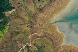
Russia is vast, encompassing 6,592,800 square miles (17,075,200 square kilometers) of tundra, taigas, steppes, plains and mountains. It's the largest nation on Earth by land area and makes up one-eighth of the planet's total inhabited land. In short, it's a difficult place to get a handle on.
A bird's-eye view, though, provides a glimpse of Russia in all its diverse glory. Here, a fall view of Russia's Ulbanskiy Bay highlights a Siberian landscape of marsh and mud near which whales are known to molt.
Volcanic Rumblings
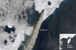
Volcanoes? Oh, yeah, Russia's got a few. This satellite image captured on March 25, 2017, shows the Kambalny volcano rumbling to life after a long period of dormancy. Taken the day after the volcano began to erupt, the image shows an ash plume flowing from the mountain's maw.
Night Lights
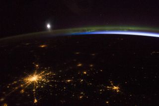
Moscow sprawls like a spider in this night image taken by an astronaut aboard the International Space Station in April 2014. The smaller cities closer to the horizon are Helsinki and St. Petersburg, while Nizhny Novgorod appears in the lower right corner. Green aurora borealis and misty bluish airglow round out the light show.
The Flooded Amur
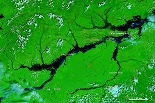
The Amur River, the 10th-longest river in the world, divides eastern Russia from northeastern China. In August 2013, the Amur flooded, an event captured by the Moderate Resolution Imaging Spectroradiometer (MODIS) on NASA's Terra satellite. This image, taken Aug. 21 when the river was at then-record height and still rising, is captured from red and near-infrared light, and the bright green land, teal clouds and dark water are all false-colored. Tens of thousands of people had to be evacuated from the flooding the month this image was taken; a few weeks later, on Sept. 7, 2013, hundreds had to flee their homes in the city of Komsomolsk-on-Amur after a dam broke. At the peak of flooding in early September, the water level in the Amur reached 26.6 feet (810 centimeters), blowing past the previous record, set in 1897, of 21 feet (642 cm), according to the Russian Times.
Fiery Interlude
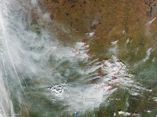
Floods aren't Russia's only natural disasters. The summer and fall of 2016 saw wildfires spreading like, well, wildfire in Siberia. The MODIS instrument on NASA's Terra satellite caught this view, too. It shows smoke from dozens of fires raging north of Ust'-Kut in western Russia. The red dots indicate likely fires, as detected by ground-temperature measurements.
Fire in Spring
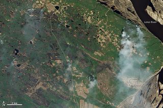
Another shot of Russian fires taken from space shows burning from the far east. Captured May 24, 2011, by NASA's Earth Observing-1 satellite, this image shows a dwindling fire near the Lena River, the 11th-longest river on Earth.
A Blossoming Delta
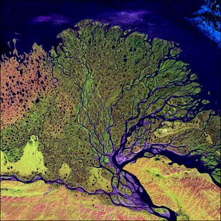
Speaking of the Lena River, this is how that mighty waterway ends: in a maze-like delta. This false-color image from July 2000 shows the delta emptying into the Laptev Sea, part of the Arctic Ocean. The twisty maze of waterways, mud and marsh stretches over 12,355 square miles (32,000 square kilometers) and is home to dozens of fish species and migratory birds.
Sign up for the Live Science daily newsletter now
Get the world’s most fascinating discoveries delivered straight to your inbox.
Volcano Stains
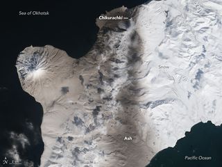
On March 29, 2016, Chikurachki volcano, a stratovolcano on an island south of the Kamchatka Peninsula, went ka-boom. The volcano had been quiet for about a year before the eruption, according to NASA's Earth Observatory. This satellite image from Landsat 8 shows snow stained with ash from the eruption, which sent plumes 2 miles (4 km) into the sky.
River in Transition
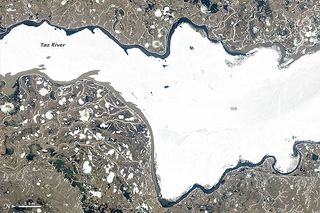
Russia's Taz River, a small river that flows through western Siberia into the Tazovskaya Guba estuary, becomes a sheet of ice in the winter. In the summer thaw, the change is dramatic: This image, taken June 18, 2013, by the Operational Land Imager on the Landsat 8 satellite, shows water pooling behind the ice as the frozen mass begins to crack and break. Brownish sediment flows can be seen in the thawed area.
Before the Deluge
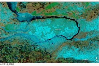
On April 14, 2005, snow and ice cover a bend in Russia's Volga River, Europe's longest river. This false-colored image captured by MODIS on NASA's Terra Satellite shows snow and ice as blue and land as brown or green, depending on the vegetation cover. This image shows the Volga before the spring flaw, when it would begin to flood…
After the Flood
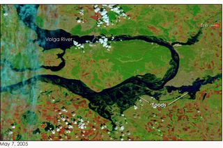
… with disastrous consequences for those nearby. This image is taken at the same spot as the previous view of the Volga, and by the same instrument on NASA's Terra Satellite, but on April 14, 2005. A few weeks of spring warmth have melted the snow and swollen the banks of the river. The most extreme flooding is seen on the lower right hand side of the photograph. According to NASA's Earth Observatory, hundreds of people were evacuated from their homes to escape the rising waters.

Stephanie Pappas is a contributing writer for Live Science, covering topics ranging from geoscience to archaeology to the human brain and behavior. She was previously a senior writer for Live Science but is now a freelancer based in Denver, Colorado, and regularly contributes to Scientific American and The Monitor, the monthly magazine of the American Psychological Association. Stephanie received a bachelor's degree in psychology from the University of South Carolina and a graduate certificate in science communication from the University of California, Santa Cruz.
Most Popular


