
 Live Science Plus


What's the tallest wave ever recorded on Earth?
This wave was taller than the Empire State Building.


A massive wave breaks.
In July 1958, an 8.3-magnitude earthquake at the Fairweather Fault rocked Alaska's southern coast. The ground-shaking event caused a massive landslide at nearby Lituya Bay, which triggered a devastating tsunami that ripped through the narrow body of water and killed five people.
The colossal wave leveled trees on the steep slopes surrounding the bay up to a maximum height of 1,719 feet (524 meters) above sea level — higher than New York's Empire State Building (which stands at 1,454 feet, or 443 m). This is known as the runup height, or the height the wave reaches after it makes landfall.
"It is the largest wave ever recorded and witnessed by eyewitnesses," Hermann Fritz, a professor of civil and environmental engineering at the Georgia Institute of Technology who specializes in tsunamis and hurricanes, told Live Science. There have likely been larger waves in Earth's history, which can be inferred from geological deposits, but these are open to interpretation, he added.

Fritz was the lead author of a study published in 2009 in the journal Pure and Applied Geophysics that recreated the Lituya Bay tsunami using a specialized 1:675 scale laboratory tank mimicking the shape of the bay. The team found that the maximum height of the wave responsible for leveling the trees was around 492 feet (150 m) tall, which makes it taller than any wave crest recorded on Earth.
Related: What countries and cities will disappear due to rising sea levels?
For the tsunami to reach this height, the landslide that triggered it would have likely dumped around 1.1 billion cubic feet (30 million cubic meters) of rock into Lituya Bay, the researchers estimated. But while the extreme scale of the landslide provided the force to create such a massive wave, the shape of the bay is the real reason why the wave was so tall, Fritz said.

An aerial photo of Lituya Bay. The stripped back treeline created by the wave is visible around the water's edge.
Lituya Bay is a fjord — a long and narrow coastal inlet with steep sides that was created by an ancient glacier. The bay is around 9 miles (14.5 kilometers) long and around 2 miles (3.2 km) across at its widest point. It has a maximum depth of 722 feet (220 m) and is connected to the Gulf of Alaska by a 984-feet-wide (300 m) opening. The landslide that triggered the 1958 tsunami occurred at Gilbert Inlet, at the end of the fjord furthest from the ocean.
Get the world’s most fascinating discoveries delivered straight to your inbox.
During a typical landslide-generated tsunami, the resulting wave radiates out in a fan shape. But the narrow shape and steep slopes of Lituya Bay, as well as the point of origin, meant that the full power of the wave was channeled in one direction. And because there was nowhere else for the water to go, it was pushed up the surrounding slopes, which is why it had such a massive runup height, Fritz said.
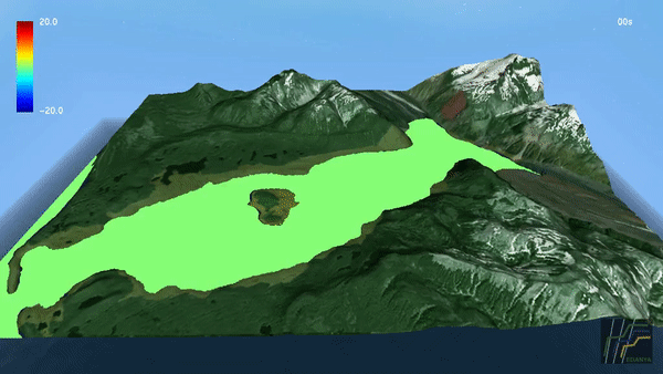
In 2019, a study published in the journal Natural Hazards and Earth System Sciences created a visual simulation of the wave using computer models (see below).
This type of extreme wave is known as a megatsunami — a term initially coined by the media that refers to extremely large waves caused by landslides or volcanic island collapses, Fritz said.
Landslide-generated tsunamis are much rarer than tectonic tsunamis, which are caused by disruptions to the seafloor due to the movement of tectonic plates (such as the 2011 tsunami in Japan) and make up more than 90% of all tsunamis, Fritz said. Landslide-generated tsunamis are much more short-lived than tectonic tsunamis, he added.
"Landslide-generated tsunamis can be very large near the source but decay rapidly," Fritz said. On the other hand, tectonic tsunamis start as small waves only a few feet high that travel enormous distances and increase in height when they reach the coast, he noted.
During the Lituya Bay tsunami, the wave had reduced to a height of less than 328 feet (100 m) by the time it reached the narrow opening of the fjord and did not radiate much further into the Gulf of Alaska, Fritz said.
Related: Why isn't Earth perfectly round?
The 1958 tsunami was not the first of its kind in Lituya Bay. Geologists had previously discovered evidence of smaller tsunamis that occurred there in 1853, 1854 and 1936, but all evidence of these was washed away by the much bigger megatsunami, according to a report by the Western States Seismic Policy Council (WSSPC).

Wave damage on the south shore of Lituya Bay.
A handful of people managed to survive the tsunami despite being on boats in the bay when the landslide occurred, either by riding out the wave or fleeing through the mouth of the bay, according to WSSPC. After the wave had dissipated, it took three weeks before the site was deemed safe enough for researchers to survey, and when it was finally considered safe, researchers described millions of uprooted trees floating in the bay.
Other record-breaking waves
On Oct. 29, 2020, Portuguese surfer António Laureano broke the record for the tallest wave ever surfed when he rode a 101.4-foot-high (30.9 m) wave at Nazaré, a town in western Portugal. The waves were so big they were visible from space and were photographed by Landsat 8, a satellite operated by NASA and the U.S. Geological Survey, Live Science previously reported. (This record is not officially recognised by the World Surf League (WSL) because no WSL officials were on hand to confirm the height of the wave.)

A satellite image of massive 7-story waves crashing into the Portuguese coast near Nazaré on Oct. 29, 2020.
The official largest open-water wave ever recorded measured 62.3 feet (19 m) and was detected by a buoy in the North Atlantic on Feb. 17, 2013, according to the World Meteorological Organization.
On Nov. 17, 2020, a buoy near Vancouver Island, British Columbia, recorded the most extreme rogue wave ever. (A rogue wave is an unusually tall wave more than twice as high as the surrounding swells that spontaneously appear in the open ocean.) This wave was 58 feet (17.6 m) tall, making it more than three times as tall as surrounding swells, which researchers described as a "once in a millennium" occurrence, Live Science previously reported.
RELATED MYSTERIES
The world's largest tidal bore — a phenomenon in which an incoming tide reverses the current of a river and forms a wave, or waves, of water that travel up the river — occurs in China's Qiantang River during the eighth month of the lunar calendar, where the wave normally reaches around 29.5 feet (9 m) high, according to The Atlantic. However, on Aug. 22, 2013, an additional surge from a typhoon caused the wave to reach around 65.6 feet (20 m) high and injured 30 spectators, according to Sky News.
The largest artificial waves ever made by humans are generated at the Delta Flume wave generator in the Netherlands, which opened in 2015. This 984-foot-long (300 m) tank, which holds 2.4 million gallons (9 million liters) of water, creates waves with a maximum height of 16.4 feet (5 m), according to the BBC.
Originally published on Live Science.

Harry is a U.K.-based senior staff writer at Live Science. He studied marine biology at the University of Exeter before training to become a journalist. He covers a wide range of topics including space exploration, planetary science, space weather, climate change, animal behavior and paleontology. His recent work on the solar maximum won "best space submission" at the 2024 Aerospace Media Awards and was shortlisted in the "top scoop" category at the NCTJ Awards for Excellence in 2023. He also writes Live Science's weekly Earth from space series.