Ancient Travelers Created These Sprawling Circular Structures During Pit Stops
Get the world’s most fascinating discoveries delivered straight to your inbox.
You are now subscribed
Your newsletter sign-up was successful
Want to add more newsletters?

Delivered Daily
Daily Newsletter
Sign up for the latest discoveries, groundbreaking research and fascinating breakthroughs that impact you and the wider world direct to your inbox.

Once a week
Life's Little Mysteries
Feed your curiosity with an exclusive mystery every week, solved with science and delivered direct to your inbox before it's seen anywhere else.

Once a week
How It Works
Sign up to our free science & technology newsletter for your weekly fix of fascinating articles, quick quizzes, amazing images, and more

Delivered daily
Space.com Newsletter
Breaking space news, the latest updates on rocket launches, skywatching events and more!

Once a month
Watch This Space
Sign up to our monthly entertainment newsletter to keep up with all our coverage of the latest sci-fi and space movies, tv shows, games and books.

Once a week
Night Sky This Week
Discover this week's must-see night sky events, moon phases, and stunning astrophotos. Sign up for our skywatching newsletter and explore the universe with us!
Join the club
Get full access to premium articles, exclusive features and a growing list of member rewards.
Dotting the desert landscape of southern Peru are mysterious circles, some half a football field across. Now, researchers have found that these strange dirt markings were probably made by on-the-go travelers passing along the area's footpaths long ago.
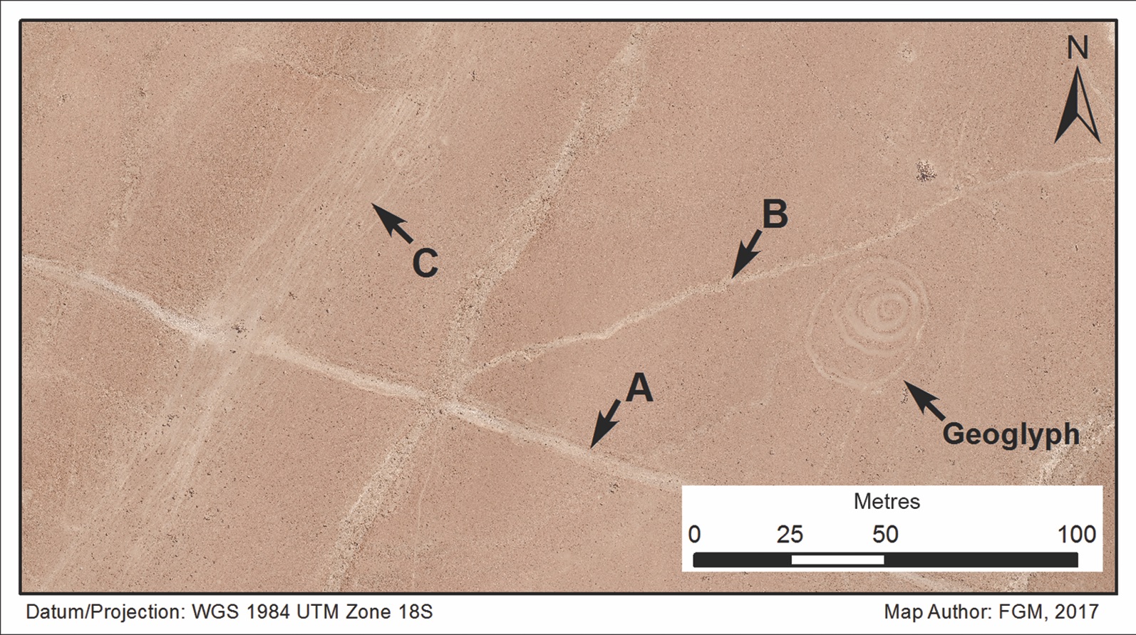
The circular geoglyphs are positioned along these old transport routes, researchers reported today (Oct. 24) in the journal Antiquity. The marks may have been made over many centuries, from as early as A.D. 200 to as late as A.D. 1400.
"People are doing these geoglyphs 'on the road' in both senses of the term," said study co-author Justin Jennings, the curator of New World archaeology at the Royal Ontario Museum in Toronto. "They're in the midst of travel, and they're doing this work, and of course, when you're in the midst of travel, you're doing it at a pit stop," he added, explaining the close link between geoglyphs and roadways. [See Photos of the Mysterious Circles in Peru]
Strange circles
Jennings and his team are working on a larger project on long-distance transport in Peru in the time before Spanish colonization. Travel in this era occurred on foot, with llamas as beasts of burden. The current study focused on the Sihuas Valley in southern Peru. The researchers used a combination of fieldwork, drone imagery and satellite images to precisely map the location of ancient footpaths and circular geoglyphs, which range in size from 9.8 feet to 180 feet (3 to 55 meters) in diameter.
The geoglyphs are easily and quickly made, Jennings told Live Science. They're constructed by simply moving aside rocks and dirt from the reddish-tan ground, exposing a lighter layer of sediment beneath the surface. Sometimes, the circles contain broken pottery or small caches of painted stones, as if someone had made an offering.
The geoglyphs somewhat resemble the famous Nazca Lines, also in southern Peru, which were also made by moving aside the top sediment. But the Nazca Lines are much more complicated than Peru's circles, depicting animals such as jaguars and monkeys and reaching up to 1,200 feet (370 m) long. [See Images of the Mysterious Nazca Lines]
After mapping the circular geoglyphs and pathways, the researchers in the new study drew virtual "buffer zones" around the remnants of the paths. The scientists then counted the number of geoglyphs that appeared in each zone, from within 82 feet (25 m) all the way to within 656 feet (200 m). The measurements seemed to indicate that the geoglyphs were more likely to be close to a path than far from one. To be sure, the investigators also generated 1,000 random points on their maps for comparison's sake.
Get the world’s most fascinating discoveries delivered straight to your inbox.
The geoglyphs were "very strongly associated with [paths] compared to what we would expect for random points," said study co-author Peter Bikoulis, a graduate student in anthropology at the University of Toronto.
Rest stop
One-ringed geoglyphs were the most common, Bikoulis told Live Science, but there were also geoglyphs made of two or three concentric circles; those tended to contain more artifacts.
The geoglyphs were often found at what Jennings called "inflection points," where the path or view changed. They were particularly frequent at spots where the paths crested a couple thousand feet (800 m) from valleys up to the flat "pampa" landscape.
"You're climbing for probably about an hour or so of a fairly steep climb, and you finally get up there," Jennings said. "Now, it's fairly flat. You can see all these great snowcapped peaks. It's a very different vista. It's a moment of change, a moment of rest."
Even today, herders in the Andes sometimes create "apachetas," or stone cairns in which they might leave a cigarette or pour out a bit of alcohol as an offering for mountain spirits, Jennings said. The circular geoglyphs may have been made with similar motivations, he said. Perhaps, these points felt sacred to long-ago travelers, and these people were moved to mark their paths as they rested along the way.
The geoglyphs are hard to date precisely, Jennings said, but they seem to come mostly from between around A.D. 600 and 1000, a time known as the Late Intermediate Period when people were traveling farther and trading goods across the region. Today, many of the llama trails those people created are disappearing as irrigation and agriculture take over the pampa plain. The researchers in the new study are working quickly to document the region by drone and satellite before these ancient markings vanish.
"All of these relationships that we can, that are so important, are going [away]," Jennings said.
Originally published on Live Science.

Stephanie Pappas is a contributing writer for Live Science, covering topics ranging from geoscience to archaeology to the human brain and behavior. She was previously a senior writer for Live Science but is now a freelancer based in Denver, Colorado, and regularly contributes to Scientific American and The Monitor, the monthly magazine of the American Psychological Association. Stephanie received a bachelor's degree in psychology from the University of South Carolina and a graduate certificate in science communication from the University of California, Santa Cruz.
 Live Science Plus


