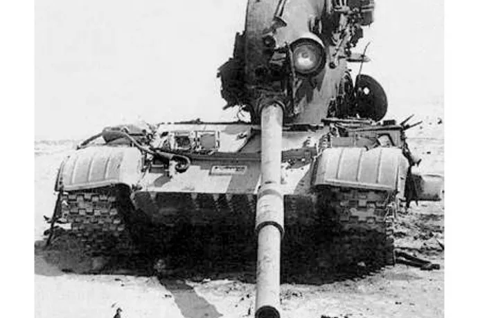
An Iraqi T-62 destroyed by 3rd Armored Division fire during the Gulf War’s Battle of 73 Easting in February 1991. The battle’s name refers to a particular north–south line on a map in the middle of the desert as opposed to a town, roadway or some other physical reference point.
(Image credit: Courtesy of 3rd Armored Division Public Affairs Office. Photo by Roland Gautier, 3AD PA0 1991.)
Twenty-five years ago U.S.-led Coalition forces launched the world's first "space war" when they drove Iraqi troops out of Kuwait. Although the actual fighting did not take place in the upper reaches of the atmosphere, satellite-based global positioning systems (GPS) played a critical role in the Coalition's rapid dismantling of Saddam Hussein's military during the 1991 Persian Gulf War. Without their orbiting eyes in the sky U.S. troops in particular would have had a much more difficult time navigating, communicating and guiding their weapons across the hundreds of kilometers of inhospitable, windswept desert battlefields in Kuwait and Iraq.
GPS would change warfare and soon became an indispensible asset for adventurers, athletes and commuters as well. The navigation system has become so ubiquitous, in fact, that the Pentagon has come full circle and is investing tens of millions of dollars to help the military overcome its heavy dependence on the technology. GPS's relatively weak signals are often unreliable and susceptible to interference, also known as "jamming." This has prompted the Defense Advance Research Projects Agency (DARPA) to begin developing navigational aids that function when satellite access is unavailable.
In January 1991, months after Iraq's invasion and occupation of neighboring Kuwait put the international community on alert, the U. S. and more than a dozen other countries launched Operation Desert Storm. The weeks-long air offensive unleashed stealth bombers, cruise missiles and laser-guided "smart" bombs on Iraq's communications networks, weapons plants and oil refineries. Clearing Hussein's forces out of Kuwait, however, required ground fighting, a daunting prospect for the Coalition members unaccustomed to desert warfare. "The introduction of GPS was particularly timely for U.S. forces in the Gulf War, primarily to address the age-old question of where am I, and where am I going?" says Col. Anthony Mastalir, vice commander of the 50th Space Wing, U.S. Air Force Space Command based at Schriever Air Force Base in Colorado. Schriever houses the master control station used to determine U.S. GPS satellite orbits and update their navigation instructions. "That information is especially important when you have very few landmarks or reference points as the troops did."
The U.S. military faced several challenges when the ground campaign began on February 24, 1991. For starters, U.S. Army artillery units assigned to fire missiles on enemy defenses and clear the way for infantry troops historically required a day or so to survey a battlefield and set up munitions. This would not be the case in Kuwait as the infantry's armored tanks, trucks and other vehicles moved swiftly, capable of traveling upward of 50 kilometers per hour. Such speeds would require artillery guns to be quickly set up, fired and moved to the next site. Failure to do that meant the infantry would not get enough artillery support in advance of engaging the Iraqis. Fears that the enemy would resort to chemical weapons against the Coalition's infantry only accentuated the need for efficient artillery cover. The Pentagon was counting on GPS to help solve this problem.
Another challenge involved a key component of the U.S.'s ground strategy—moving infantry and artillery into even less hospitable areas of the desert in order to outflank and encircle Iraqi forces. GPS would be crucial to helping ground troops "navigate through terrain that the Iraqis weren't bothering to defend because they didn't think anyone could find their way through there," says Marc Drake,a retired U.S. Air Force major who served as chief of operational analysis for the 2nd Space Operations Squadron during the Gulf War. The squadron operates Schriever's master control station as well as the network of worldwide monitoring stations and ground antennas that control and support the U.S.'s GPS satellite constellation.
Mom and dad, please send GPS
Sign up for the Live Science daily newsletter now
Get the world’s most fascinating discoveries delivered straight to your inbox.
The Army's decision to rely on GPS was a big gamble. A fully operational GPS constellation requires 24 satellites, something the U.S. would not achieve until April 1995. In early 1991 the U.S. Air Force's Navstar (Navigation System Using Timing and Ranging) constellation included only 16 satellites, and six of those were older research and development units repurposed to help with the war effort. Unlike today's 24/7 GPS coverage, the satellites in the original Navstar constellation could align long enough to provide about 19 hours each day. Accuracy would be within 16 meters, give or take, better than earlier GPS systems that had a several kilometers margin of error but not quite on par with today's to-the-centimeter precision.
Signal issues aside, GPS receivers were also in short supply. For starters, there were only 550 PSN-8 Manpack GPS receivers to go around. Troops fortunate enough to be issued Manpacks mounted these eight-kilogram devices—which cost $45,000 apiece—to their vehicles. A second, more portable option was the 1.8-kilogram AN/PSN-10 Small Lightweight GPS Receiver (SLGR), or "slugger." The military had about 3,500 of the Trimble Navigation–made SLGR devices available for use in the Gulf War. "You would hear stories about Air Force, Navy and Army personnel having mom and dad send them civilian GPS receivers so they could find their way out there," says Drake, who currently serves as a space vehicle operations support manager at Schriever. They would fasten the devices to their Humvees or tanks using Velcro, screws or duct tape as they maneuvered through unfamiliar territory. One of the most popular was the $3,000NAV 1000M Receiver, which Magellan Corp. had been selling to boaters, hikers and other adventurers since the late 1980s.
How GPS works
GPS consists of three components: satellites, receivers and ground control stations. Navstar currently has 31 operational satellites that orbit at about 20,000 kilometers above Earth every 12 hours. The constellation uses six equidistant orbital planes, with four satellites in each plane, Mastalir says. GPS satellite signals carry a time code marked by their atomic clocks, which essentially keep time by measuring the oscillations of atoms. The clocks enable each satellite in the Navstar constellation to continuously broadcast a signal that includes the time and the satellite's exact position.
GPS receivers—whether they are installed in ships at sea or embedded in wristwatches—calculate their latitude, longitude and altitude by measuring the relative time delay of signals broadcast by at least four different satellites. Ground control, meanwhile, consists of five monitoring stations, three ground antennas and Schriever's master control station, which communicates with the satellites via the ground antennas.
Navigating victory
Although GPS accuracy and reliability today is a lot better than it was 25 years ago, the coalition's gamble paid off. During the ground war, which lasted only about 100 hours, GPS receivers helped greatly with land navigation and artillery support, which was part of the massive bombardment that Iraqi soldiers referred to as "steel rain"” GPS supplemented or even replaced the artillery surveyor's compass, telescopelike aiming circle, slide rule and other tools of the trade. GPS was also at the heart of new artillery weapons including the Army Tactical Missile System, which debuted during the Gulf War, had a range of about 270 kilometers and used Navstar satellite guidance to home in on its targets.
A NAVSTAR GPS satellite undergoing pre-launch testing
(Image credit: Courtesy United States Air Force)
Satellite-based navigation proved its mettle in helping the U.S. Army's VII Corps and XVIII Airborne Corps initiate a flanking maneuver—which different military leaders called the "Hail Mary" or "left hook"—in which troops navigated far to the west of the point in southern Kuwait where the Iraqis expected coalition forces to attack. With only 3,000 GPS devices available for its contingent of 40,000 tanks, Bradley fighting vehicles, howitzer guns and cavalry, the Army units advanced more than 200 kilometers in two days through largely uncharted desert before engaging the Iraqi Republican Guard in the decisive Battle of 73 Easting on February 26. The battle's name provides some insight into how much the coalition relied on advanced navigational aids just to reach the enemy—"73 easting" is a north–south line on a map in the middle of the desert as opposed to a town, roadway or some other physical reference point.
GPS jamming
Coalition troops also got a glimpse of GPS's greatest weakness during the Gulf War. Iraqi forces installed jammers, for example, on top of landmarks such as Saddam Hussein's palaces to prevent them from being hit, Mastalir says. This helped the military realize early on that it would have to further develop its laser-guided munitions and other weapons that acquire targets when GPS is unavailable, he adds. Jamming disrupts a receiver's ability to pick up data from the satellites by adding more noise to the signal transmission. Tinkering with the signal-to-noise ratio is not difficult, given how weak GPS signals generally are by the time they reach Earth. Such signals have been compared with the amount of light given off by a 25-watt bulb, as seen from about 20,000 kilometers away.
Jamming can, to some degree, be countered by increasing signal strength and using antennas that can better discriminate between signal and noise. At the same time, however, the Pentagon recognizes the danger of relying too heavily on satellite-based GPS. DARPA, which helped miniaturize GPS receivers in the 1980s and developed ways to add GPS guidance to munitions, is now investing in new types of inertial and self-calibrating sensors that could continue to accurately track a receiver's position when satellite service is not an option. This includes the $50-millionAtomic Clocks with Enhanced Stability (ACES) program to develop portable, battery-powered atomic clocks the size of cell phones. The goal is for the next generation of clocks to be 1,000 times more stable than current models and to accurately maintain time and navigation information in devices even when cut off from satellite communications.
If DARPA's vision comes to fruition, military units could someday be equipped with both atomic clocks and GPS receivers to help them find their way through hostile territory.