


Australian Airport, Highway Still Underwater
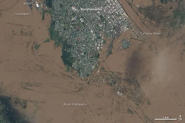
The airport, Bruce Highway, and large swaths of Rockhampton remained underwater on Jan. 9, 2011, according to a NASA statement. Days of rain pushed the Fitzroy River over its banks, inundating parts of the city near the Queensland coast.
Damage to Bruce Highway was not confined to Rockhampton; on Jan. 11, 2011, ABC News Australia reported that other parts of the highway, in southeastern Queensland, were expected to remain underwater for some time.
In this image, acquired by the Advanced Land Imager (ALI) on NASA's Earth Observing-1 (EO-1) satellite on Jan. 9, 2011, isolated islands of cityscape poke through murky brown flood waters.
The Fitzroy River cuts through the upper right quadrant of the image, and just west of the river, relatively high land remains above the flood. All around that area, flood water predominates, including areas east of the river.
Rockhampton was just one of many Australian communities reeling from floods , according to news reports. Farmers along the Sunshine Coast were stranded by high waters that washed out roads. Authorities in Brisbane, Australia's third-largest city, told residents to evacuate in anticipation of the worst flooding in several decades.
- 'Inland Tsuanmi' Rips Through Australian City
- More Than 200,000 Affected by Flood Waters in Queensland
- Rockhampton Inundated by Water from Fitzroy River
Get the world’s most fascinating discoveries delivered straight to your inbox.
