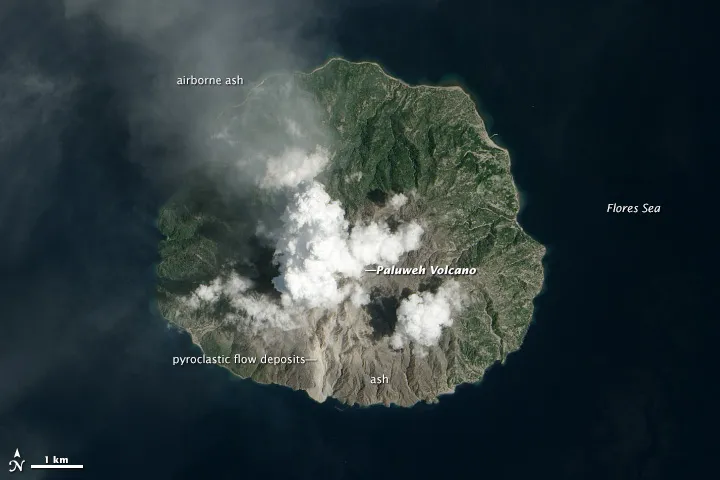
Fresh ash coats the flanks of remote Paluweh volcano in Indonesia in an image from space captured Feb. 12 by NASA's Earth Observing-1 (EO-1) satellite.
The stratovolcano erupted on Feb. 2 and 3, sending superheated gas and rock ―a fast-moving plume called a pyroclastic flow ― racing to the sea. The flow's brownish-gray scar is visible in the natural-color image snapped by the satellite's Advanced Land Imager (ALI). A tongue of debris extends into the sea at the base of the flow.
Paluweh volcano (also known as Rokatenda) is on the northern part of Palue Island. Most of the island remains covered in green vegetation, but ash ejected during the eruption has destroyed many of the island's crops, NASA's Earth Observatory reported.
Latest Videos From
The island has approximately 10,000 people, living in eight villages. Several of the villages are threatened by the eruption, according to VolcanoDiscovery.com. The report cites an analysis published by the Indonesian Volcanological Survey that concludes the eruption caused the collapse of about 25 percent of the volume of the volcano's dome, about 35 million cubic feet (1 million cubic meters). Should the dome continue to grow, a future collapse could send a pyroclastic flow into the villages, the report concludes.
The volcano's last eruption had been in 1985, according to the Smithsonian's Global Volcanism Program. Beginning last October, the volcano sent out warnings, with an increase in small earthquakes and ash ejected from the summit, the Earth Observatory said.
Reach Becky Oskin at boskin@techmedianetwork.com. Follow her on Twitter @beckyoskin. Follow OurAmazingPlanet on Twitter @OAPlanet. We're also on Facebook and Google+.