It's quick and easy to access Live Science Plus, simply enter your email below. We'll send you a confirmation and sign you up for our daily newsletter, keeping you up to date with the latest science news.
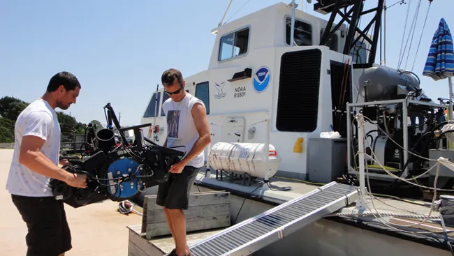
Enlarge Image A 3-D camera developed at WHOI's Advanced Imaging and Visualization Lab (AIVL) is brought aboard the NOAA vessel SRVx. This and other AIVL cameras are expected to provide the first optical survey of ships sunk by German U-Boats during World War II off the North Carolina coast.
The seas off the North Carolina coast are known to be filled with World War II shipwrecks. But this battleground hasn't been thoroughly studied — until now.
These waters are known as the Graveyard of the Atlantic and Torpedo Junction. Here, dozens of ships — mostly merchant vessels — were sunk by German U-boats.
The remains of those ships, along with several U-boats, rest on the Atlantic Ocean seafloor. The National Oceanic and Atmospheric Administration (NOAA) estimates that from January to August 1942, more than 50 vessels were lost to the U-boat assault.
"They sank ships at will," said study team member Eva Kovacs of the Woods Hole Oceanographic Institution (WHOI) in Massachusetts. Kovacs is part of a 10-day mission to provide NOAA with the first 3-D optical survey of the undersea wrecks off the North Carolina coast.
"We hope to get a full 3-D picture of several sites so that NOAA can go back and assess the wrecks' condition and the impact of the ships on the marine environment," Kovacs said. "We're breaking new ground."
Research team members get in the water to test the Remotely Operated Vehicle (ROV) that will carry the cameras developed at WHOI's Advanced Imaging and Visualization Lab.
The Battle of the Atlantic mission is the first study of a maritime battleground off the coast of North Carolina, according to NOAA officials.
The mission, currently in progress aboard the NOAA vessel SRVx, employs a remotely operated vehicle (ROV) outfitted with several underwater 3-D and high-definition camera systems developed by the mission scientists. The team expects to survey wrecks as deep as 600 feet (183 meters).
Sign up for the Live Science daily newsletter now
Get the world’s most fascinating discoveries delivered straight to your inbox.
WHOI hopes to provide dramatic still and video images, which will be the detailed data needed to fashion the large, two- and three-dimensional mosaic maps of the shipwreck sites. The maps will help the researchers monitor changes in the vessels over the years.
The dive team will be on the lookout for one of the last of the known German U-boats, which has yet to be found.
For the science geek in everyone, Live Science offers a fascinating window into the natural and technological world, delivering comprehensive and compelling news and analysis on everything from dinosaur discoveries, archaeological finds and amazing animals to health, innovation and wearable technology. We aim to empower and inspire our readers with the tools needed to understand the world and appreciate its everyday awe.