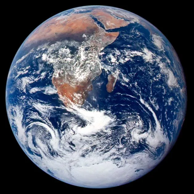
One of the most famous photographs ever taken was shot by an Apollo 17 astronaut in 1972 while on his way to the moon. Dubbed "Blue Marble," the image shows southern Africa and Antarctica beneath swirling white clouds and against a backdrop of deep blue ocean.
Since then, NASA has released new images of Earth's full profile every few years, naming them Blue Marble in honor of that first stunning look at our home in space.
The latest in the series is called "Blue Marble: Next Generation" and shows a cloud-free Earth changing through all four seasons.
Latest Videos FromLive Science
In the span of a single year, snowlines advance and retreat. Entire continents freeze and thaw. In spring, the green blush of vegetation spreads across some of their faces. The blush is vibrant throughout summer, is fading by fall and gone come winter. The images also reveal biological and physical processes that work together to determines the look of our planet.
The project has also generated artistic close-ups of various Earth features.
Earth through the Seasons [How the images were made]
Fall Countries like Indonesia and Thailand in southeast Asia are still damp and green from the last of the summer monsoons. In northern Asia, temperatures are dropping and snow clouds are assembling, in preparation for their winter march south. The greenish landscapes of the northeastern United States and western Canada are turning a brownish-red as leaves in those regions change color, die and drop from their branches.
Winter Most of the Northern Hemisphere is covered with snow. Notable exceptions are the East Coast of the United States and parts of western Europe, especially Scotland and Britain. A band of circulating warm water known as the Gulf Stream flows along the coast of these regions, shielding them from the full brunt of winter. In Africa, rain clouds have migrated south and the bottom tip of that continent is the greenest it will be all year. In summer, those clouds will return north, taking their gift of rain with them.
Spring Snowlines in North America and Asia begin to pull back. A faint green blush is forming in the southeastern United States; by summer, it will have spread across the entire continent. Rain clouds in South America are shifting from west to east, making the eastern parts of that continent noticeably greener.
Summer The curtain of snow that covered most of Asia during the winter lifts, reduced by the rays of the Sun to a small crown of white near the North Pole. Even Alaska can’t resist the warmth of summer. Rain clouds have returned to Northern Africa and the middle of the continent is a more vibrant shade of green than before. The world’s great deserts -- the Sahara in Africa, the Gobi in Asia and most of Australia -- change little through the seasons and look much the same in summer as they did in winter.
About the images: Each image is a composite stitched together from thousands of photographs taken with NASA's Moderate-resolution Imaging Spectroradiometer (MODIS) satellite. The images were compiled at NASA's Goddard Space Flight Center in Maryland. To give an unobstructed view of Earth's surface, multiple satellite passes and digital manipulations were used to remove clouds.