New Type of El Niño Emerges as Climate Changes

A relatively new type of El Niño, featuring warmer waters in a different part of the Pacific Ocean, is becoming more common and stronger, according to a new study that suggests the development may help scientists tease out the relationship between El Niños and climate change.
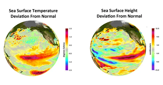
The warm surface waters of this El Niño type are in the central equatorial Pacific rather than in the eastern equatorial Pacific. The intensity of El Niños in the central Pacific has nearly doubled since 1982, with the most intense event occurring in 2009-10, according to the study.
The stronger El Niño is alternately known as the "Central Pacific El Niño," "warm-pool El Niño," "dateline El Niño" or "El Niño Modoki" — Japanese for "similar but different." Scientists say it helps explain a steady rise in central Pacific sea surface temperatures observed over the past few decades — a trend often attributed to global warming.
Article continues below"These results suggest climate change may already be affecting El Niño by shifting the center of action from the eastern to the central Pacific," said study team member Michael McPhaden of the National Oceanic and Atmospheric Administration in Seattle. "El Niño's impact on global weather patterns is different if ocean warming occurs primarily in the central Pacific, instead of the eastern Pacific.
"If the trend we observe continues," McPhaden added, "it could throw a monkey wrench into long-range weather forecasting, which is largely based on our understanding of El Niños from the latter half of the 20th century."
Despite a rise in sea surface temperatures during El Niño years, no significant temperature increases were seen in years when ocean conditions were neutral or when El Niño's cool-water counterpart, La Niña, was present.
"Our study concludes the long-term warming trend seen in the central Pacific is primarily due to more-intense El Niños rather than a general rise of background temperatures," said study team member Tong Lee of NASA's Jet Propulsion Laboratory in Pasadena, Calif.
Get the world’s most fascinating discoveries delivered straight to your inbox.
Scientists measured changes in El Niño intensity since 1982. They analyzed NOAA satellite observations of sea surface temperature, checked against and blended with directly measured ocean temperature data. The strength of each El Niño was gauged by how much its sea surface temperatures deviated from the average.
Further research is needed to evaluate the impacts of these increasingly intense El Niños and determine why these changes are occurring, Lee said.
"It is important to know if the increasing intensity and frequency of these Central Pacific El Niños are due to natural variations in climate or to climate change caused by human-produced greenhouse gas emissions," Lee said.
El Niño, Spanish for "the little boy," is the oceanic component of a climate pattern (called the El Niño-Southern Oscillation) that appears in the tropical Pacific Ocean on average every three to five years.
El Niños can influence global weather patterns and the occurrence and frequency of hurricanes, droughts and floods. El Niños can even raise or lower global temperatures by as much as 0.4 degrees Fahrenheit (0.2 degrees Celsius).
The study was detailed in the July 24 edition of the journal Geophysical Research Letters.
- The World's Weirdest Weather
- Earth in the Balance: 7 Crucial Tipping Points
- In Images: Reading the Clouds
This article was provided by OurAmazingPlanet, a sister site to LiveScience.
