


Images: Lost Medieval City Discovered Near Angkor Wat
Lost City

A lost city known only from inscriptions that existed some 1,200 years ago near Angkor in what is now Cambodia has been uncovered using airborne laser scanning. The previously undocumented cityscape, called Mahendraparvata, is hidden beneath a dense forest on the holy mountain Phnom Kulen, meaning Mountain of the Lychees, located in Siem Reap Province (shown here).
Angkor Wat

The cityscape came into clear view along with a vast expanse of ancient urban spaces that made up Greater Angkor, the large area where one of the largest religious monuments ever constructed — Angkor Wat (shown here), meaning "temple city" — was built between A.D. 1113 and 1150.
Hidden Beneath a Forest
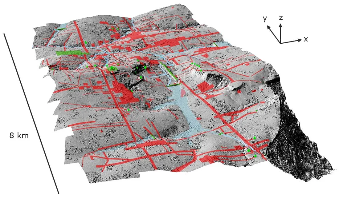
Here, the lost city of Mahendraparvata revealed in a shaded relief map of terrain beneath the vegetation in the Phnom Kulen acquisition area, with elevation derived from the lidar digital terrain model at 0.5 meter resolution and 4x vertical exaggeration. Green denotes previously documented archaeological features; areas shaded red contain newly documented features indicative of an extensive urban layout.

Koh Ker

The lidar also uncovered the 10th-century "ephemeral capital" of Koh Ker. (This map shows previously identified features in the central area.)
New City Features

The lidar data also revealed an array of previously undocumented elements of the capital of Koh Ker, such as ponds, reservoirs and mounds that are "open," or not delimited in space by any form of enclosure. (Red denotes a modern road.)
Major Temple Sites

Here, a shaded relief map of terrain beneath the vegetation at major temple sites in the Angkor region, with elevation derived from the lidar digital terrain model at 1 m resolution. Top left: Bakong (late 9th century). Top center: Phnom Bakheng (late 9th century). Top right: Pre Rup (mid-10th century). Middle left: Chau Srei Vibol (11th to 12th centuries). Middle center: Beng Mealea (early 12th century). Middle right: Angkor Wat (mid-12th century). Bottom left: Preah Khan (late 12th century). Bottom center: Ta Prohm (late 12th century). Bottom right: Bayon (late 12th to 13th centuries). Red denotes modern linear features such as roadways and canals.
Get the world’s most fascinating discoveries delivered straight to your inbox.
Jeanna Bryner is managing editor of Scientific American. Previously she was editor in chief of Live Science and, prior to that, an editor at Scholastic's Science World magazine. Bryner has an English degree from Salisbury University, a master's degree in biogeochemistry and environmental sciences from the University of Maryland and a graduate science journalism degree from New York University. She has worked as a biologist in Florida, where she monitored wetlands and did field surveys for endangered species, including the gorgeous Florida Scrub Jay. She also received an ocean sciences journalism fellowship from the Woods Hole Oceanographic Institution. She is a firm believer that science is for everyone and that just about everything can be viewed through the lens of science.