Close-Up: Irene Breaches Outer Banks
Get the world’s most fascinating discoveries delivered straight to your inbox.
You are now subscribed
Your newsletter sign-up was successful
Want to add more newsletters?
Delivered Daily
Daily Newsletter
Sign up for the latest discoveries, groundbreaking research and fascinating breakthroughs that impact you and the wider world direct to your inbox.
Once a week
Life's Little Mysteries
Feed your curiosity with an exclusive mystery every week, solved with science and delivered direct to your inbox before it's seen anywhere else.
Once a week
How It Works
Sign up to our free science & technology newsletter for your weekly fix of fascinating articles, quick quizzes, amazing images, and more
Delivered daily
Space.com Newsletter
Breaking space news, the latest updates on rocket launches, skywatching events and more!
Once a month
Watch This Space
Sign up to our monthly entertainment newsletter to keep up with all our coverage of the latest sci-fi and space movies, tv shows, games and books.
Once a week
Night Sky This Week
Discover this week's must-see night sky events, moon phases, and stunning astrophotos. Sign up for our skywatching newsletter and explore the universe with us!
Join the club
Get full access to premium articles, exclusive features and a growing list of member rewards.
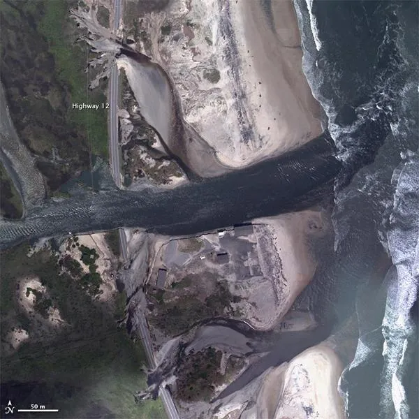
Flood waters from Hurricane Irene sliced through portions of Highway 12 on North Carolina's Hatteras Island. Highway 12, which extends along the Outer Banks, is the only road connecting Hatteras Island to the mainland. At Pea Island National Wildlife Refuge, water and shifting sand damaged the highway in multiple locations.
This aerial photo, acquired by the National Oceanic and Atmospheric Administration (NOAA) on August 28, 2011, is part of a larger project to assess damage from Hurricane Irene along the U.S. East Coast. The largest breach in Highway 12 appears midway down the image where water flows between Pamlico Sound and the Atlantic Ocean. North and south of this breach, the road has been compromised in other places, by what appears to be a combination of water and sand.
Damage to Highway 12 stranded at least 2,500 residents of Hatteras Island, according to news reports. The Los Angeles Times reported that, in at least three locations, water surged from Pamlico Sound through the barrier island toward the Atlantic Ocean.
The News Observer reported that new gaps in Highway 12 are near sites of ancient inlets that have alternately opened and closed for centuries. The Island Free Press reported that the largest breach in Hatteras Island is estimated at more than 100 feet (30 meters) wide and 8 feet (2.5 meters) deep.
In addition to a breached highway, residents of Hatteras Island also had to cope with downed power lines. On August 29, state officials started a ferry service to shuttle emergency personnel to and from Hatteras. As of that date, no injuries had been reported on the island.
- Could Katia Threaten the East Coast?
- Atmospheric Forces Conspire to Make 2011 a Wild Year
- Will Hurricane Irene's Name Be Retired?
Get the world’s most fascinating discoveries delivered straight to your inbox.

