Plane View: Air Traffic Tracked in Real Time from Satellites

Get the world’s most fascinating discoveries delivered straight to your inbox.
You are now subscribed
Your newsletter sign-up was successful
Want to add more newsletters?

Delivered Daily
Daily Newsletter
Sign up for the latest discoveries, groundbreaking research and fascinating breakthroughs that impact you and the wider world direct to your inbox.

Once a week
Life's Little Mysteries
Feed your curiosity with an exclusive mystery every week, solved with science and delivered direct to your inbox before it's seen anywhere else.

Once a week
How It Works
Sign up to our free science & technology newsletter for your weekly fix of fascinating articles, quick quizzes, amazing images, and more

Delivered daily
Space.com Newsletter
Breaking space news, the latest updates on rocket launches, skywatching events and more!

Once a month
Watch This Space
Sign up to our monthly entertainment newsletter to keep up with all our coverage of the latest sci-fi and space movies, tv shows, games and books.

Once a week
Night Sky This Week
Discover this week's must-see night sky events, moon phases, and stunning astrophotos. Sign up for our skywatching newsletter and explore the universe with us!
Join the club
Get full access to premium articles, exclusive features and a growing list of member rewards.
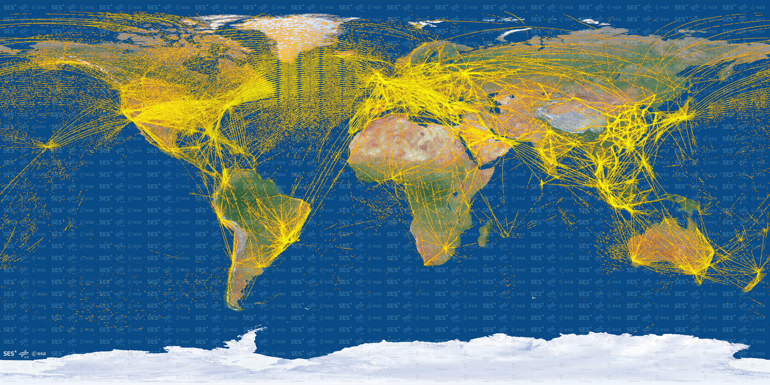
A stunning image of more than 15,000 airplane flights from around the world shows that satellite tracking of commercial aircraft is moving closer to reality.
The problem with tracking airplanes by ground-based radar is made tragically clear every time planes vanish. When a plane flies over remote regions or vast oceans, the aircraft may disappear from the radar tracking system. In March 2014, Malaysia Airlines Flight 370 disappeared from radar over the Gulf of Thailand and its whereabouts remain unknown.
The National Transportation and Safety Board recommended a solution in a January report: real-time satellite tracking. Private companies already sell transmitters that can send signals from planes to satellites every minute. In the United States, the NextGen (Next Generation Air Transportation System) satellite-based tracking system is scheduled for a full rollout by 2025. [The 5 Real Hazards of Air Travel]
Now, using signals from an experimental Automatic Dependent Surveillance–Broadcast (ADS-B) transmitter, the European Space Agency (ESA) has tracked more than 15,000 aircraft over two years with a minisatellite, the agency said in a statement. The satellite picked up more than 25 million positions from the planes, the ESA said.
"We've shown that detection of aircraft can work from space with no showstoppers, despite the fact that these signals were never designed to be picked up from so far away," Toni Delovski of the DLR German Aerospace Center said in the statement.
The satellite flight patterns reveal where to find peace and quiet from screaming jet engines: the Sahara, the Himalayas, Madagascar, Alaska's Brooks Range and, perhaps, a bare patch of Nevada desert (presumably the system isn't tracking military jets, which often buzz this corner of the Southwest).
ADS-B signals are part of a new satellite tracking system that is being phased in worldwide for the commercial aviation industry. The technology will both send and receive broadcasts from aircraft, giving flight information such as speed, position and altitude. The equipment could replace secondary radar and help improve safety by providing more accurate positions and better surveillance.
Get the world’s most fascinating discoveries delivered straight to your inbox.
Primary radar determines a plane's position by bouncing signals off the aircraft. Secondary radar uses a transponder to send location information directly from the plane.
The ESA flight-tracking experiment was a proof-of-concept study that tagged along on the Proba-V minisatellite. The minisatellite, measuring less than 35 cubic feet (1 cubic meter), was launched in 2013 to chart global vegetation changes.
Follow Becky Oskin @beckyoskin. Follow Live Science @livescience, Facebook & Google+. Originally published on Live Science.

 Live Science Plus


