 Live Science Plus


You are now subscribed
Your newsletter sign-up was successful
Want to add more newsletters?

Delivered Daily
Daily Newsletter
Sign up for the latest discoveries, groundbreaking research and fascinating breakthroughs that impact you and the wider world direct to your inbox.

Once a week
Life's Little Mysteries
Feed your curiosity with an exclusive mystery every week, solved with science and delivered direct to your inbox before it's seen anywhere else.

Once a week
How It Works
Sign up to our free science & technology newsletter for your weekly fix of fascinating articles, quick quizzes, amazing images, and more

Delivered daily
Space.com Newsletter
Breaking space news, the latest updates on rocket launches, skywatching events and more!

Once a month
Watch This Space
Sign up to our monthly entertainment newsletter to keep up with all our coverage of the latest sci-fi and space movies, tv shows, games and books.

Once a week
Night Sky This Week
Discover this week's must-see night sky events, moon phases, and stunning astrophotos. Sign up for our skywatching newsletter and explore the universe with us!
Join the club
Get full access to premium articles, exclusive features and a growing list of member rewards.
Iceland's changing landscape
Only a few satellites orbit near the poles, high enough to catch Iceland's fiery lava fountains in action. Here are some of the best of the bunch.
New country

Iceland's Holuhraun eruption seen in a combined before-and-after radar image from the TerraSAR-X satellite.
Fresh glow

Infrared views of the Bardarbunga volcanic eruption. The false color image was snapped Sept. 6 by NASA's Landsat 8 satellite. The photo seen here combines shortwave infrared, near-infrared and green light.
Spying sputtering lava
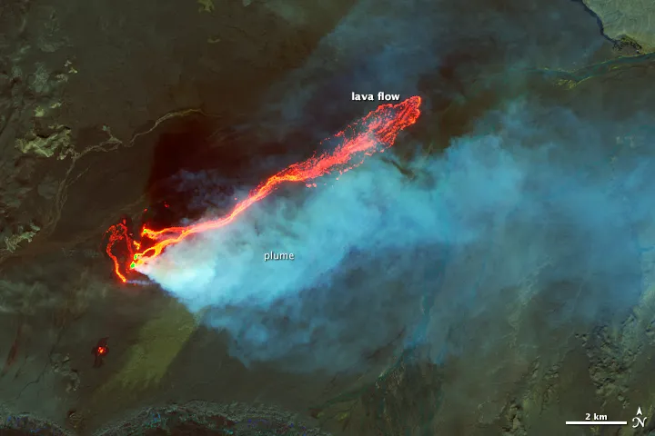
A zoom view of the previous Landsat image highlights glowing lava against Holuhraun's black sands and glacier-fed river channels.
Fire and ice

A natural color version of the same image of Iceland's volcanic eruption, captured Sept. 6 by NASA's Landsat 8 satellite.
Noxious gas
The MODIS instrument on NASA's Terra satellite caught a long trail of sulfur dioxide gas spewing from the eruption on Sept. 5.
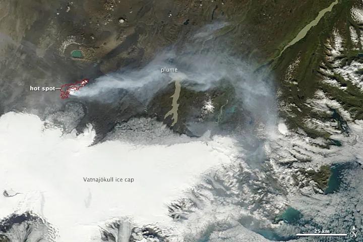
Roiling hotspot

The hot lava peeks through stormy clouds in another MODIS image from the Terra satellite. The image was shot Aug. 31, the day the eruption kicked into high gear.

