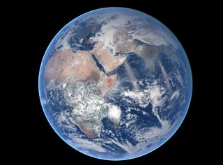
Earth's Eastern Hemisphere Stuns in Photo from Space

Earth's biggest spy may be NASA, as its satellites trek around the blue planet snapping gorgeous views and collecting gobs of data.
The Earth-orbiting Suomi NPP satellite, launched on Oct. 28, 2011, is no exception, as the instrument-clad orbiter has spit out some breathtaking shots of humanity's home planet, including one of the Eastern Hemisphere released yesterday (Aug. 20) by NASA's Earth Observatory.
On March 30, the satellite's Visible Infrared Imaging Radiometer Suite (VIIRS) captured the newly released image, which shows swirls of clouds above a blue, green and brown orb. The picture, in which Africa, the Middle East and Asia take center stage, was stitched together from data collected during eight orbits of Earth. [Earth from Above: 101 Stunning Images from Orbit]
The Suomi National Polar-orbiting Partnership (NPP) — named after late meteorologist and "father of satellite meteorology" Verner E. Suomi — involves NASA, the National Oceanic and Atmospheric Administration, and the Department of Defense. The partnership aims to build and launch the next generation of satellites to monitor Earth, collecting information on short-term weather and longer-term climate.
The minivan-size satellite, which weighs some 4,600 pounds (2,100 kilograms), circles Earth along a path that crosses the North and South Poles every 102 minutes at a distance of 512 miles (824 kilometers) above the planet. Even at that altitude, the satellite can't capture the entire Earth in one snapshot. So images collected from several passes must be put together to create mosaic scenes like the one released yesterday.
The Suomi NPP satellite has sent back a slew of jaw-dropping images of the planet, including other pictures showing Earth's Eastern and Western Hemispheres, nighttime shots revealing marine clouds hovering above the California coast, stunning lightning storms, and even a giant blaze from a train derailment in Quebec
Suomi is in good company. Already this year, two Earth-observing satellites — the Global Precipitation Measurement satellite and the Orbiting Carbon Observatory 2 — have launched.
Sign up for the Live Science daily newsletter now
Get the world’s most fascinating discoveries delivered straight to your inbox.
And three more missions are set to launch in the next six months: the ISS-RapidScat, which will launch to the International Space Station (ISS) and help with weather forecasting by measuring ocean-surface wind speed and direction; the ISS Cloud-Aerosol Transport System, which will measure aerosols and pollution in the atmosphere while on board the ISS; and the Soil Moisture Active Passive, which will provide a global map of soil moisture.
Follow Jeanna Bryner on Twitter and Google+. Follow us @livescience, Facebook & Google+. Original article on Live Science.

Jeanna served as editor-in-chief of Live Science. Previously, she was an assistant editor at Scholastic's Science World magazine. Jeanna has an English degree from Salisbury University, a master's degree in biogeochemistry and environmental sciences from the University of Maryland, and a graduate science journalism degree from New York University. She has worked as a biologist in Florida, where she monitored wetlands and did field surveys for endangered species. She also received an ocean sciences journalism fellowship from Woods Hole Oceanographic Institution.
