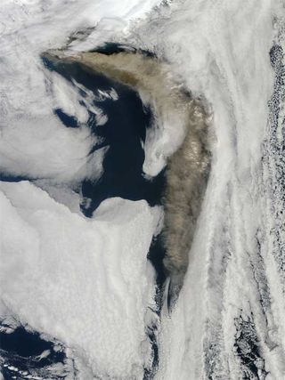
Amazing Image of Icelandic Volcano Ash

A striking image of the brownish ash cloud from Iceland's volcano, which began a fresh round of explosive eruptions this week, was captured by a NASA satellite Thursday morning.
The ash-cloud image, taken by the Moderate Resolution Imaging Spectroradiometer (MODIS) on NASA's Terra satellite shows a thick plume of ash blowing east and then south from the Eyjafjallajökull volcano. Clouds bracket the edges of the scene, but the dark blue waters of the Atlantic Ocean show in the middle, and above them, a rippling, brownish-yellow river of ash.
Ash clouds like this are impressive to see, and they can have a dramatic influence on air quality and vegetation, including crops. In Iceland, the ash from Eyjafjallajökull has settled thickly on the ground, posing a threat to livestock and wildlife. The ash has already grounded European air traffic repeatedly. On the bright side, the ash also created spectacular volcanic sunsets and mysterious lightning.
Despite their dramatic appearance, however, these ash plumes are insignificant when it comes to long-term effects on global climate, scientists say. For an eruption to have an influence on global climate, the event must be explosive enough to push sulfur dioxide into the stratosphere, which is above the altitude where rain and snow occur.
Sulfur dioxide turns into tiny droplets of sulfuric acid, which reflect sunlight back to space, and so cool the Earth. Because it doesn't rain in the stratosphere, the droplets can linger for months or years. Massive eruptions can cool the global average surface temperature by several degrees for several years.
Even when sulfur dioxide gets shot into the stratosphere, the resulting reflective particles rarely have a chance to spread around the globe. Stratospheric air generally rises above tropical latitudes, spreads toward the poles, and then sinks back toward the lower atmosphere at high latitudes.
This circulation pattern means that stratospheric particles from eruptions in the tropics have a better chance of spreading around the world, while particles from high-latitude eruptions, like Eyjafjallajökull, are more likely to quickly sink back to lower altitudes. When they re-enter the troposphere (lowest level of Earth's atmosphere), they quickly get washed out of the air by rain and snow.
Sign up for the Live Science daily newsletter now
Get the world’s most fascinating discoveries delivered straight to your inbox.
- Gallery: Iceland's Fiery Sunsets
- History's Most Destructive Volcanoes
- Top 10 Greatest Explosions Ever
Most Popular


