Hidden Maya complexes hint that the famous calendar was already in use 3,400 years ago

Ancient Central American people may have designed their cities around an early iteration of the Maya calendar.
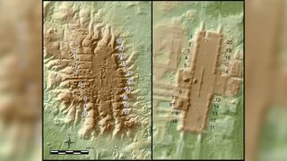
A new study of ancient population centers in western Guatemala and southern Mexico reveals 478 separate complexes, many of which seem based on a prototype city built around 1400 B.C. Many of these complexes have never been discovered, surveyed or excavated until now. But their shapes, detectable from above with a technology called lidar — which stands for "light detection and ranging" — suggest many were oriented with the sunrise on certain important days and seemed to use the number 20, — the basis of later written calendars, — as their fundamental unit.
"We don't have the written calendar at this time yet," said Takeshi Inomata, an archaeologist at the University of Arizona and the lead researcher of the new study. "[That] comes much later, several centuries later than these sites. But this is a very tantalizing sign that actually people already had a calendar system that's based on the number 20."
Related: See photos of the hidden Maya complexes
Maya calendars and Mesoamerican architecture
The calendar that seemed important in constructing these sites is not the famous Maya calendar that some claimed predicted the end of the world in 2012. That's the Maya Long Count calendar, which was designed for keeping track of very long spans of time. For shorter periods, the Maya also worked with the 260-day Tzolk'in calendar, which they used for scheduling religious rituals, and the Haab', a 365-day calendar based on Earth's rotation around the sun. The Tzolk'in and the Long Count calendars both used repeating cycles of 20 for counting the days. Written versions of the Long Count calendar are found from from A.D. 800 and later, Live Science previously reported.
Related: Photos reveal hidden Maya civilization
The sites discovered by Inomata and his colleagues are mostly much older than that. Though exact dates aren't yet known, the oldest of the sites predate 1000 B.C., and the most recent were probably built before A.D. 250, which was the beginning of the Maya Classic period, the peak of the Maya civilization.
Sign up for the Live Science daily newsletter now
Get the world’s most fascinating discoveries delivered straight to your inbox.
Many of the sites share a similar layout, with a large plaza bound by a large rectangular platform at one end and lined on the east and west with 20 smaller platforms. Twenty seems to be a significant number, Inomata said, perhaps indicating that the builders of these structures were already using the base-20 counting system.
The population centers are also often laid out to line up with the sunrise on a day related to the zenith passage, the day the sun passes directly overhead. In this region of Central America, Inomata said, that day is May 9 or May 10. The sites don't catch the sunrise on that day, but they do line up with sunrise 40 days or 60 days before the passage — multiples of 20. This suggests the architects were counting down to the zenith passage and may have been building their notions of calendar time into their city centers. Archaeologists believe the large plazas in the middle of these population centers were used for religious rituals, so an early version of the Tzolk'in may have been in use already.

Regional relations
The new research also paints a fuller picture of how civilization developed in Central America. The study region covers both Maya areas and areas that were home to the earlier Olmec people, who built colossal stone heads and pyramids over 100 feet (30 meters) high. But dense vegetation means that archaeology can be difficult, and many mounds hiding structures and artifacts blend into the landscape. In part due to this spotty archaeological record, not much is known about how the Olmec and Maya civilizations interacted. One question, Inomata said, is whether the Olmec influenced the Maya, or whether the Maya developed largely independently.
Related: Why did the Maya civilization collapse?
Another question is how social hierarchy played a role in the organized building of the city centers. It was once thought that societies became more organized and hierarchical and then settled in one place to build complex towns and cities. But, Inomata said, new research suggests that the early builders of many of these population centers were hunters, gatherers and farmers who may have moved seasonally or every few years. They did not seem to have a strict social hierarchy.
"It's not a society governed by kings, but the people get together and then do this big project," Inomata said.

Large-scale layouts
Lidar is a particularly valuable tool in Central America, Inomata said, as it involves pulsing beams of lasers toward the ground from a drone or airplane. These pulses of targeted light allow researchers to measure topography precisely, virtually stripping away vegetation in order to see the shape of the ground.
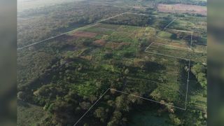
That's particularly useful in Inomata's research since many of the population centers the researchers are searching for are visible now as low mounds, perhaps a couple feet high. They're large, but their size is mostly horizontal: The larger plazas range from 0.6 miles to almost a mile long (1 to 1.6 kilometers), which is difficult to visualize from ground level.
The researchers previously conducted their own survey of eastern Tabasco in Mexico and discovered an enormous site called Aguada Fénix, Live Science reported at the time of that discovery. Aguada Fénix was a Maya site consisting of an artificial plateau 33 to 50 feet (10 to 15 m) high and 0.9 miles (1.4 km) long. It was used between 1000 B.C. and 800 B.C., an earlier start to major building projects than researchers had expected.
After the discovery, Inomata said, the team wanted to expand their search. They combed through publicly available lidar data throughout southern Mexico and western Guatemala to uncover the hundreds of new sites. The sites' layouts suggest that the people of this region were building on old ideas and influencing one another.
The influence may have grown from the earliest large site, San Lorenzo, built by the Olmec people in what is now the Mexican state of Veracruz. San Lorenzo peaked between 1400 B.C. and 1150 B.C., and here society was stratified: Elite homes sat on top of a large plateau, with humble dwellings on the plateau's terraced sides. Later sites seemed based on this basic template, with variations on the theme developing between 1000 B.C. and 350 B.C. The Maya, thought to be a less-stratified society at this time than the Olmec, used a similar blueprint of a central raised plaza bound by a pyramid or square building on one side and a long platform on the other.
But there are a lot of questions remaining about the chronology of the development, Inomata said, and excavations will be needed to answer many of them. This should keep archaeologists busy, as the study area covers 32,632 square miles (84, 516 square kilometers).
"Now, we have a much better idea about those sites and their distribution, so we really will rethink what was happening during this period," Inomata said.
The research is detailed Oct. 25 in the journal Nature Human Behavior.
Originally published on Live Science.

Stephanie Pappas is a contributing writer for Live Science, covering topics ranging from geoscience to archaeology to the human brain and behavior. She was previously a senior writer for Live Science but is now a freelancer based in Denver, Colorado, and regularly contributes to Scientific American and The Monitor, the monthly magazine of the American Psychological Association. Stephanie received a bachelor's degree in psychology from the University of South Carolina and a graduate certificate in science communication from the University of California, Santa Cruz.
