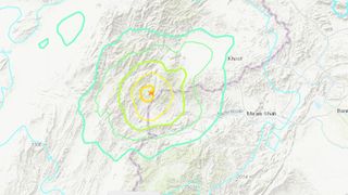
Magnitude 5.9 earthquake hits Afghanistan, killing at least 1,000
The death toll is expected to increase.

A powerful earthquake rattled eastern Afghanistan in the early hours of Wednesday morning (June 22), killing at least 1,000 people and wounding hundreds more, although casualty numbers are expected to rise. State-level disaster management officials reported at least 600 injured, while local officials put the count closer to 1,500, according to Reuters.
The European-Mediterranean Seismological Centre initially estimated the quake's magnitude to be 6.1, but the organization has since reported a slightly lower magnitude of 5.9. This latter estimate matches the one reported by the U.S. Geological Survey (USGS).
The earthquake's epicenter was about 29.1 miles (46.8 kilometers) southwest of the city of Khōst, which sits near the Afghanistan-Pakistan border, according to the USGS. Earthquakes in this region occur due to the India plate shifting northward and colliding with the adjacent Eurasia plate; the India plate moves northward at a rate of about 1.6 inches (40 millimeters) per year.
Southwest of the Himalayas, the two plates slide against each other at a slant. Based on the pattern of seismic waves from Wednesday's quake, the event mostly involved "strike-slip faulting," in which vertical fractures appear at locations where the tectonic plates have rubbed against each other horizontally, the USGS reported. The quake occurred at a relatively shallow depth of 6.2 miles (10 km).
Related: Scientists find evidence for biggest earthquake in human history
So far, most confirmed deaths from the quake have been reported in Paktika province, south of Khost province, of which Khōst is the capital city, CNN reported.
"The timing of the earthquake [in the] dark of night … and the shallow depth of 10 kilometers of its epicenter led to higher casualties," Najibullah Sadid, an Afghan water resources management expert, told CNN. Photos released from Paktika province showed the crumbled remains of houses piled up around a few surviving walls, with broken roof beams strewn about the area, CNN reported.
Sign up for the Live Science daily newsletter now
Get the world’s most fascinating discoveries delivered straight to your inbox.
"The death toll is likely to rise as some of the villages are in remote areas in the mountains and it will take some time to collect details," interior ministry official Salahuddin Ayubi told Reuters.
Originally published on Live Science.

Nicoletta Lanese is the health channel editor at Live Science and was previously a news editor and staff writer at the site. She holds a graduate certificate in science communication from UC Santa Cruz and degrees in neuroscience and dance from the University of Florida. Her work has appeared in The Scientist, Science News, the Mercury News, Mongabay and Stanford Medicine Magazine, among other outlets. Based in NYC, she also remains heavily involved in dance and performs in local choreographers' work.
Most Popular

