California's Spreading Wildfires: What Are Katabatic Winds?
What is this powerful seasonal weather pattern?

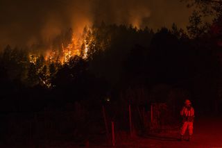
While the cause of 21 separate wildfires blazing across eight counties in northern California remains unknown, their rapid spread is tragically familiar. Many of California's fiercest wildfires occur in September and October, owed in part to a powerful seasonal weather pattern known as katabatic winds — an annual threat that creates the ideal conditions for making bad fires even worse.
Wind doesn't start fires, but it can fan the flames, often with catastrophic results. Katabatic winds take their name from the Greek word "katabasis," which means "descending." True to their name, katabatic winds' main distinction is that they fall; they begin at high, relatively cool elevations before plunging downslope. As the air whooshes downslope, it gets compressed, which causes it to become warmer and drier, and to move even faster, according to Brenda Belongie, lead meteorologist for the Predictive Services unit at the Northern California Service Center in Redding, California.
"When you take air from a higher elevation and bring it to a lower elevation, you're compressing it," Belongie told Live Science. "Anyone who has ever worked a bicycle pump is aware of what happens to the temperature of the air as you compress it: It warms up. That's why lower elevations are warmer than higher elevations. It's called the adiabatic process." [Wildfires Blaze in Northern California (Photos)]
Hurricane-force winds
Katabatic winds' swift drop in elevation results in waves of hot, dry air capable of reaching hurricane wind speeds. The strongest winds observed during the current northern California fires so far blew through Sonoma at 79 mph (127 km/h), though sustained katabatic winds tend to blow between 15 to 20 mph (24 to 32 km/h) on average, Belongie said. (A tropical storm becomes classified as a hurricane when its maximum sustained winds reach 74 mph, or 119 km/h.)
The speed at which katabatic winds fly off the hills can be detrimental to wildfire suppression efforts, especially at a time of year when natural fuels — like dried grass, brush and tree roots — cover more area in the valleys of California. According to Cal Fire spokesman Daniel Berlant, strong winds can throw burning embers half a mile forward, potentially sparking new fires and making existing ones unmanageable, reported KQED Science, a Bay Area news agency.
Perhaps just as dangerous is katabatic winds' utter lack of moisture."If the air is dry to begin with, its humidity gets ridiculously low when the winds sweep in," Belongie said. "We're talking single-digit-percentage low — and that has a very drying effect on the fuels." Without the ability to regain their moisture, ground fuels burn as the fires continue to spread, she added.
Katabatic winds make bad fires worse
The most infamous katabatic-wind events in North America are likely the Santa Ana winds, which blow westward out of the Great Basin every fall and pour hot, dry air over the mountain ranges of southern California. The Great Basin is a region bordered by the Wasatch Mountains to the east, the Sierra Nevada mountains to the west and the Snake River Plain to the north.
Sign up for the Live Science daily newsletter now
Get the world’s most fascinating discoveries delivered straight to your inbox.
The Santa Ana winds are notorious for fanning regional wildfires, including a series of blazes in October 2007 that scorched more than 500,000 acres and killed 10 people, according to Cal Fire.
In northern California, seasonal katabatic winds are colloquially called Diablo winds, likely named for the Diablo Valley east of the Bay Area through which the winds tend to pass. (The valley itself is named after the Spanish word for "devil.") Unlike the Santa Anas, Diablo winds generally originate from high-pressure systems in the Pacific Northwest and then flow south and southwest over California's Coast Ranges and other nearby peaks.
The National Weather Service predicts that the strongest winds in the ongoing crisis will hit the region late tonight (Oct. 13) and Saturday (Oct. 14), before tapering off on Sunday.
"As soon as the wind quits, the fires will quit moving," Belongie said. "Flame heights drop, the intensity drops way off, and firefighters can move in and keep it from going much further."
Original article on Live Science.

Brandon is the space/physics editor at Live Science. His writing has appeared in The Washington Post, Reader's Digest, CBS.com, the Richard Dawkins Foundation website and other outlets. He holds a bachelor's degree in creative writing from the University of Arizona, with minors in journalism and media arts. He enjoys writing most about space, geoscience and the mysteries of the universe.
Most Popular


